IMAGES TAKEN NEAR TO
Churchbalk Lane, PONTEFRACT, WF8 2RF
Introduction
This page details the photographs taken nearby to Churchbalk Lane, WF8 2RF by members of the Geograph project.
The Geograph project started in 2005 with the aim of publishing, organising and preserving representative images for every square kilometre of Great Britain, Ireland and the Isle of Man.

There are currently over 7.5m images from over14,400 individuals and you can help contribute to the project by visiting https://www.geograph.org.uk
Image Map
Images are licensed for reuse under creativecommons.org/licenses/by-sa/2.0
Notes
- Clicking on the map will re-center to the selected point.
- The higher the marker number, the further away the image location is from the centre of the postcode.
Image Listing (12 Images Found)
Images are licensed for reuse under creativecommons.org/licenses/by-sa/2.0
Image
Details
Distance
1
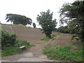
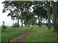
Choice of paths
To the left is a well-used but non-definitive path towards Bates Hill. To the right is the public footpath to Carleton
Image: © John Slater
Taken: 20 Sep 2013
0.04 miles
2
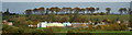
Pontefract Rookeries in Autumn
Here's the Rookeries, viewed from a horizontal (rather than 'end-on') perspective. The photo is taken from Ackworth road. Below the Rookeries, Carleton High's cladding matches the autumn colours!
Image: © Phillip Beadham
Taken: 25 Oct 2020
0.13 miles
3
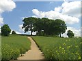
The Rookeries
This walk is one of Pontefract's hidden gems.
Image: © Phillip Beadham
Taken: 21 May 2020
0.15 miles
4

The Rookeries School , Carleton, Pontefract
This is a view of the school from the Rookeries.
Image: © Bill Henderson
Taken: 27 Jun 2008
0.19 miles
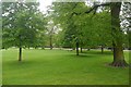
5
Skeletal winter trees, at Pontefract Rookeries
It's February's final day, and the trees look striking, with their skeletal branches. On the right, between the trees, you can faintly see Pontefract town centre, with St. Giles' church tower visible. The blue shape, on the path's right, is a broken plastic sledge, evidence of the snow this year.
Image: © Phillip Beadham
Taken: 28 Feb 2021
0.19 miles
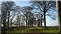
6
Public Footpath Through The Rookeries
Image: © Bill Henderson
Taken: 27 Jun 2008
0.20 miles
7

The Rookeries Junior & Infant School, Carleton
Image: © Bill Henderson
Taken: 24 Jul 2012
0.20 miles
8
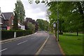
Carleton Road, Carleton
Passing Carleton Green.
Image: © Richard Webb
Taken: 21 May 2016
0.20 miles
10
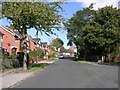
Carleton Crest - off Carleton Road
Image: © Betty Longbottom
Taken: 8 Oct 2008
0.22 miles