IMAGES TAKEN NEAR TO
Hill Top, KNOTTINGLEY, WF11 9AQ
Introduction
This page details the photographs taken nearby to Hill Top, WF11 9AQ by members of the Geograph project.
The Geograph project started in 2005 with the aim of publishing, organising and preserving representative images for every square kilometre of Great Britain, Ireland and the Isle of Man.

There are currently over 7.5m images from over14,400 individuals and you can help contribute to the project by visiting https://www.geograph.org.uk
Image Map
Images are licensed for reuse under creativecommons.org/licenses/by-sa/2.0
Notes
- Clicking on the map will re-center to the selected point.
- The higher the marker number, the further away the image location is from the centre of the postcode.
Image Listing (161 Images Found)
Images are licensed for reuse under creativecommons.org/licenses/by-sa/2.0
Image
Details
Distance
1
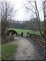
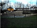
Entrance to Knottingley Amphitheatre
This entrance is off Hill Top near to Gaggs Bridge.
Image]
The Amphitheatre is set below the road level adjacent to the canal.
Image]
Image]
Image: © bernard bradley
Taken: 28 Jan 2009
0.01 miles
2
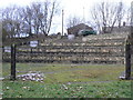
Knottingley Amphitheatre
Knottingley Amphitheatre looking run down and neglected.
Access is from the canal side or from Hill Top.
Image]
Image: © bernard bradley
Taken: 28 Jan 2009
0.01 miles
3
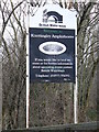
Welcome to Knottingley Amphitheatre
Welcome sign at the entrance to Knottingley Amphitheatre
Image: © bernard bradley
Taken: 28 Jan 2009
0.01 miles
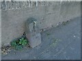
4
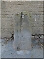
Old milestone
This eroded and plateless milestone on Hill Top, Knottingley, the A645, is one of only two survivors from the 1758 Wakefield to Weeland tollroad. Weeland was a ferry crossing of the River Aire at SE 606 239 to Hirst Courtney. Now only a track leads from Main Street, Hensall to the river. An inset rectangular plate would have had the legend PONT/3/WAKD/12. A bench mark can just be made out near ground level underneath the plate recess.
Image: © Chris Minto
Taken: 10 Apr 2022
0.02 miles
5
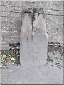
Old Milestone by the A645, Knottingley
Stone post (plate lost) by the A645, in parish of KNOTTINGLEY (WAKEFIELD District), Knottingley, between two bridges over Aire and Calder Canal; opposite St Michael's Catholic Church, on pavement, back to wall near "Amphitheatre", on South side of road. Erected by the Wakefield & Weeland turnpike trust in the 18th/19th century.
Inscription once read:-
(PONT)
(3)
(WAKD)
(12)
Carved benchmark on front below plate.
Milestone Society National ID: YW_WKWL12.
Image: © C Minto
Taken: 21 May 2003
0.02 miles
6
St Michael's church, Knottingley
A Roman Catholic church built, probably in the 1950s, on the site of a former inn.
Image: © Stephen Craven
Taken: 13 Aug 2022
0.02 miles
7

The final march
Procession leaving Knottingley town hall marking the end of deep coal mining in Great Britain after the closure of Kellingley Colliery.
Image: © derek dye
Taken: 20 Dec 2015
0.02 miles
9
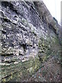
Quarry Face
This view taken from the canal footpath shows the eastern abutment upon which Gaggs Bridge is built. The rock is a limestone and historically has been extensively quarried in this area.
Image]
Image: © bernard bradley
Taken: 28 Jan 2009
0.02 miles
10
Old milestone on Hill Top, Knottingley
Now lacking its original marker plate, and cracked, but an old map shows that it originally marked 3 miles to Pontefract and 12 to Wakefield. The Milestone Society's photo explains that it is 'one of only two survivors from the 1758 Wakefield to Weeland tollroad'. Milestone ID: YW_WKWL12
Image: © Stephen Craven
Taken: 13 Aug 2022
0.02 miles