IMAGES TAKEN NEAR TO
Doctors Lane, CASTLEFORD, WF10 2HJ
Introduction
This page details the photographs taken nearby to Doctors Lane, WF10 2HJ by members of the Geograph project.
The Geograph project started in 2005 with the aim of publishing, organising and preserving representative images for every square kilometre of Great Britain, Ireland and the Isle of Man.

There are currently over 7.5m images from over14,400 individuals and you can help contribute to the project by visiting https://www.geograph.org.uk
Image Map
Images are licensed for reuse under creativecommons.org/licenses/by-sa/2.0
Notes
- Clicking on the map will re-center to the selected point.
- The higher the marker number, the further away the image location is from the centre of the postcode.
Image Listing (39 Images Found)
Images are licensed for reuse under creativecommons.org/licenses/by-sa/2.0
Image
Details
Distance
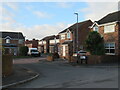
2
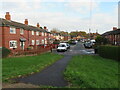
Blands Terrace
Quiet residential street in Allerton Bywater. The houses here would appear to be of the type built for a local authority in the 1930's when this was a mining area.
Image: © Gordon Hatton
Taken: 25 Nov 2022
0.04 miles
4
Grange Park Close
Modern houses tucked into a corner of Allerton Bywater village.
Image: © Gordon Hatton
Taken: 25 Nov 2022
0.06 miles
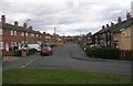
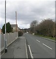
6
Houses on Blands Terrace
Seen from The Lines, a former railway line, now a permitted bridleway.
Image: © Christine Johnstone
Taken: 5 Jan 2013
0.09 miles
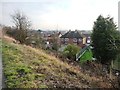
7
A missing bridge at Doctor's Lane
The former Ledston branch railway line had a bridge here. The permitted bridleway, The Lines, does not.
Image: © Christine Johnstone
Taken: 5 Jan 2013
0.10 miles
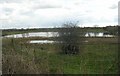
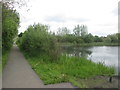
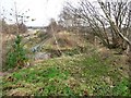
9
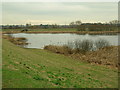
Allerton Bywater
These lakes, ponds, ings, have formed over the former pit under the village, depressed since the closure of the mines, but now undergoing resurgence with the advent of Millennium Village ("the place that's going to be the place to be") - built by English Partnerships and comprising new affordable housing, commercial and industrial premises.
Image: © Paul Johnston-Knight
Taken: 13 Feb 2006
0.12 miles