IMAGES TAKEN NEAR TO
Scrubbitts Park Road, RADLETT, WD7 8JW
Introduction
This page details the photographs taken nearby to Scrubbitts Park Road, WD7 8JW by members of the Geograph project.
The Geograph project started in 2005 with the aim of publishing, organising and preserving representative images for every square kilometre of Great Britain, Ireland and the Isle of Man.

There are currently over 7.5m images from over14,400 individuals and you can help contribute to the project by visiting https://www.geograph.org.uk
Image Map
Images are licensed for reuse under creativecommons.org/licenses/by-sa/2.0
Notes
- Clicking on the map will re-center to the selected point.
- The higher the marker number, the further away the image location is from the centre of the postcode.
Image Listing (45 Images Found)
Images are licensed for reuse under creativecommons.org/licenses/by-sa/2.0
Image
Details
Distance
1

Cat on wheelie bin, Radlett
She sits on her wheelie bin on the north side of the Crosspath (approximately halfway along from the junction with Scrubbitts Park Road towards the junction with Gills Hill Road / Station Road) greeting passers-by with loud squeaks and squawks.
Image: © John Copleston
Taken: 20 Feb 2010
0.02 miles
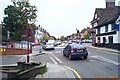
2
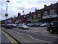
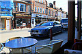
Shops on Watling Street, Radlett
The middle of the shopping centre strung along the A5
Image: © David Howard
Taken: 12 Jun 2008
0.09 miles
3
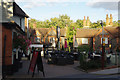
The Red Lion, Radlett
The forecourt of the Red Lion has outdoor seating looking on to Watling Street, the old Roman road that forms the spine of this small town. The Red Lion dates from 1906 and was originally a temperance house. In addition to a bar and restaurant it has 14 guest bedrooms.
Image: © Stephen McKay
Taken: 27 Oct 2017
0.10 miles
4
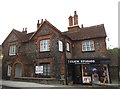
Click Studios on Watling Street, Radlett
Image: © David Howard
Taken: 28 Jul 2016
0.11 miles
5
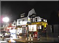
Businesses on west side of Watling Street, Radlett
Looking from the window of 'Costa Coffee' towards a point roughly midway between Station Approach and the junction with Shenley Road
Image: © John Copleston
Taken: 21 Oct 2010
0.11 miles
6
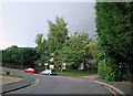
Woodfield Road, Radlett
Looking towards the southern (underground car park) entrance to Scrubbitts Square.
Image: © John Copleston
Taken: 17 Aug 2010
0.12 miles
8
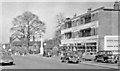
Radlett High St., 1956
View northward on the A5 (now A5183), near the War Memorial, nearly 60 years ago.
Image: © Ben Brooksbank
Taken: 23 Mar 1956
0.12 miles
9
Radlett: Watling Street (1)
A profusion of road signs and street furniture greets the motorist at this busy mini-roundabout at the junction of Watling Street with Shenley Hill. Viewed looking southwards along the Roman Road this was the old A5 but was downgraded to the A5183 some time ago. The stone column of Radlett's War Memorial is just visible to the left of the roundabout in front of the shops.
Image: © Nigel Cox
Taken: 14 Oct 2005
0.12 miles