IMAGES TAKEN NEAR TO
Wentbridge Path, BOREHAMWOOD, WD6 4ET
Introduction
This page details the photographs taken nearby to Wentbridge Path, WD6 4ET by members of the Geograph project.
The Geograph project started in 2005 with the aim of publishing, organising and preserving representative images for every square kilometre of Great Britain, Ireland and the Isle of Man.

There are currently over 7.5m images from over14,400 individuals and you can help contribute to the project by visiting https://www.geograph.org.uk
Image Map (Loading...)


Getting Data...Please wait
Leaflet Map data © OpenStreetMap
Images are licensed for reuse under creativecommons.org/licenses/by-sa/2.0
Notes
- Clicking on the map will re-center to the selected point.
- The higher the marker number, the further away the image location is from the centre of the postcode.
Image Listing (18 Images Found)
Images are licensed for reuse under creativecommons.org/licenses/by-sa/2.0
Image
Details
Distance
1
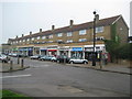
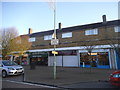
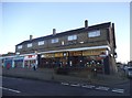
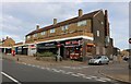
Borehamwood: Leeming Road shops
There is a Francis Frith image of these shops taken around 1965 here http://www.francisfrith.com/borehamwood/photos/leeming-road-shopping-parade-c1965_B408040/ but taken from the other end of the parade.
Image: © Nigel Cox
Taken: 15 Apr 2009
0.11 miles
3
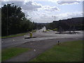
Aycliffe Road, Borehamwood
Looking towards the mini-roundabout and steep hill below
Image: © David Howard
Taken: 20 Aug 2009
0.14 miles
6
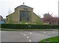
Borehamwood: Church of St Michael & All Angels
The foundation stone for the church, which is in Brook Road, was laid by Princess Margaret in October 1954, and the church was completed and consecrated in December 1955.
(NB From a mapping point of view the church's location on the Ordnance Survey's 1:50,000 scale map, as shown with a cross, is a little misplaced.)
Image: © Nigel Cox
Taken: 15 Apr 2009
0.20 miles
8
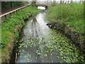
Borehamwood: Tykes Water and Leeming Park
This is Tykes Water in Leeming Park viewed looking downstream towards the Aycliffe Road bridge with what appears to be a fine collection of water lilies about to bud. Tykes Water is also known as Borehamwood Brook here.
Image: © Nigel Cox
Taken: 15 Apr 2009
0.21 miles
9
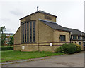
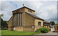
Church of St Michael and All Angels, Borehamwood
Built in 1954 to a design by architect N. F. Cachemaille-Day.
Image: © Jim Osley
Taken: 18 May 2017
0.21 miles
10
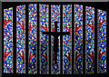
St Michael & All Angels, Borehamwood - Stained glass window
Image: © John Salmon
Taken: 26 Jun 2016
0.21 miles