IMAGES TAKEN NEAR TO
Deacons Hill Road, BOREHAMWOOD, WD6 3JF
Introduction
This page details the photographs taken nearby to Deacons Hill Road, WD6 3JF by members of the Geograph project.
The Geograph project started in 2005 with the aim of publishing, organising and preserving representative images for every square kilometre of Great Britain, Ireland and the Isle of Man.

There are currently over 7.5m images from over14,400 individuals and you can help contribute to the project by visiting https://www.geograph.org.uk
Image Map
Images are licensed for reuse under creativecommons.org/licenses/by-sa/2.0
Notes
- Clicking on the map will re-center to the selected point.
- The higher the marker number, the further away the image location is from the centre of the postcode.
Image Listing (11 Images Found)
Images are licensed for reuse under creativecommons.org/licenses/by-sa/2.0
Image
Details
Distance
1
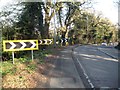
Borehamwood: A411 Barnet Lane chevrons at Deacons Hill
The A411 Barnet Lane does a little chicane here, down the slope to the right, then left again just visible at the bottom.
Image: © Nigel Cox
Taken: 7 Mar 2015
0.05 miles
2
Deacons Hill, Elstree
Sloping up from Elstree towards more open land on Woodcock Hill. This is part of the London Loop path on a 2km roadside section linking footpaths on Borehamwood Golf Course and Scratchwood Nature Reserve.
Image: © Des Blenkinsopp
Taken: 17 Jul 2013
0.05 miles
3
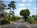
The London LOOP in Borehamwood
This is Deacon's Hill Road. The London LOOP runs down this road on its way from Scratch Wood, passing close to Elstree & Borehamwood station at the far end of Deacon's Hill Road, before heading out into the Green Belt again.
Image: © Marathon
Taken: 26 Sep 2018
0.05 miles
5
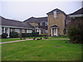
Deacons Heights, Elstree
One of the two blocks, the other is on the right of this.
Image: © David Howard
Taken: 20 Feb 2008
0.09 miles
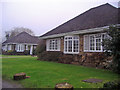
6
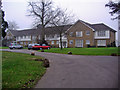
9 - 12 Deacons Heights, Elstree
1 - 8 are out of sight to the right, and are behind security gates.
Image: © Robin Webster
Taken: 14 Jun 2015
0.09 miles
7
Deacons Heights, Elstree
Modern development along Barnet Lane
Image: © David Howard
Taken: 20 Feb 2008
0.14 miles
8
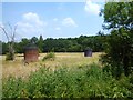
Tunnel Air Shafts
A railway tunnel is below this field. The two brick structures are air shafts.
The red brick one is labelled "fast" and the grey one "slow".
Image: © Des Blenkinsopp
Taken: 17 Jul 2013
0.19 miles
9
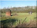
Borehamwood: Elstree Tunnels Airshafts
Viewed from the A411 Barnet Lane these are two of the airshafts on the former Midland Railway's Elstree Tunnels. The airshafts are about 30 metres apart giving some idea of the separation between the two tunnel bores. The railway was originally opened in 1868 with just one tunnel bore and the nearer red brick airshaft is over that tunnel, so is presumably contemporary with it. Shortly after, and certainly by 1898 as it is shown on the Ordnance Survey map of the time, the second tunnel was built to cope with increased railway traffic, and the far darker brick airshaft is on the newer bore.
Given that the ground level on the A411 here is about 119 metres above sea level and that it is about 92 metres in the vicinity of Elstree and Borehamwood Station one would guess that the tunnel track level is roughly about 25 metres down from the ground level at the airshafts.
Additional details provided by John Webb: "For your information, the Slow line tunnel was opened to traffic on the 23rd June 1895."
Image: © Nigel Cox
Taken: 7 Mar 2015
0.20 miles
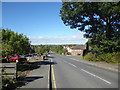
10
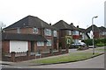
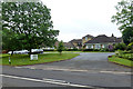
The Rise, Elstree
Taken from Deacons Hill Road.
Image: © David Kemp
Taken: 12 May 2010
0.22 miles