IMAGES TAKEN NEAR TO
Chaucer Grove, BOREHAMWOOD, WD6 2FG
Introduction
This page details the photographs taken nearby to Chaucer Grove, WD6 2FG by members of the Geograph project.
The Geograph project started in 2005 with the aim of publishing, organising and preserving representative images for every square kilometre of Great Britain, Ireland and the Isle of Man.

There are currently over 7.5m images from over14,400 individuals and you can help contribute to the project by visiting https://www.geograph.org.uk
Image Map (Loading...)


Getting Data...Please wait
Leaflet Map data © OpenStreetMap
Images are licensed for reuse under creativecommons.org/licenses/by-sa/2.0
Notes
- Clicking on the map will re-center to the selected point.
- The higher the marker number, the further away the image location is from the centre of the postcode.
Image Listing (26 Images Found)
Images are licensed for reuse under creativecommons.org/licenses/by-sa/2.0
Image
Details
Distance
1
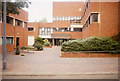
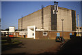
The Fire Research Station (11)
Entrance to the Clarke Building complex. On the left on the ground floor was the FRS computing section, above it the Library. On the right the offices and smaller laboratories. Straight ahead the main entrance and above it a large plant room.
Image: © John Webb
Taken: Unknown
0.05 miles
2
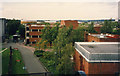
The Fire Research Station (9)
View of the Eastern side of the Fire Research Station Site, developed and bought into use in 1978. On the right nearest the camera is the end of the Lecture Theatre, just beyond that is the Publicity/AV/Photography building, and across the centre lies the Clarke building, the major offices and laboratory complex and named after a former Director. The area nearest the camera was part of a private sports ground, the area beyond the Clarke building disused allotments. Beyond the site left of centre is one of the gasholders in Station Road and on the distant far right is Borehamwood's only tower block. Closer views of the Clarke building at Image and Image
The East arm of the present Coleridge Way follows roughly the line of the site road.
Image: © John Webb
Taken: Unknown
0.05 miles
3
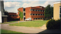
The Fire Research Station (10)
The Clarke building complex seen from the west. Contained numerous special laboratories, offices, the FRS Library, computing facilities and stores. Opened 1978.
Image: © John Webb
Taken: Unknown
0.05 miles
4
The Fire Research Station (4)
Specialist laboratories next to the main building. From left to right the 'Hydraulics Lab', the 'Radiation Lab' and the 'Chemical Engineering Lab' used respectively for water and fire-fighting foam matters, heat radiation and smoke movement matters and the last for flame arresters and other work related to chemical works.
Image: © John Webb
Taken: Unknown
0.08 miles
5
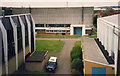
The Fire Research Station (8)
A closer view of the Models Laboratory seen in Image; this side lies just within this grid square. From left to right we have the round pump house - an electric 500 gallons/minute pump feeding hoses and hydrants in the Lab - over it is a 5000 gallon water tank feeding the pump. The rest of the single-storey extension housed toilets, instrument and work rooms. Near the camera is the air inlet for the wind area across the end of the building; the single storey extension on the far side houses the electric motor driving the fan and its controls. (The chimney is on a building further away.)
The South ends of two of the present blocks of flats in Coleridge Way lie on the area this building once occupied. The East arm of Coleridge Way follows the line of the site road heading off at the right of the picture.
(Photo scanned direct from a 35mm Agfa colour slide.)
Image: © John Webb
Taken: Unknown
0.09 miles
6
The Fire Research Station (6)
The 'Models Laboratory', built 1958, seen from the main building. At one time the largest fire test building in the world. So-called because models of buildings were constructed in it for fire tests. It had a section of the roof opened by a hydraulics mechanism to vent gases from these tests. The blue doors with a large concrete surround visible in the photo cover an opening into the building - on the far side a 12ft (4m) diameter electric fan could draw in air through the opening on this side across the building at speeds of up to 30mph to see the effect of wind on burning objects. A closer view of this building is in Image
The building lies on the grid line between this square and TQ1996
Image: © John Webb
Taken: Unknown
0.09 miles
7
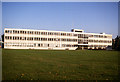
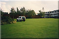
The Fire Research Station (7)
The 'Main Building' at the Fire Research Station, built 1960. Housed administration, library, statistics and various small laboratories. The large grass area in front of the building provided space for relaxation for staff at lunchtime and saw cricket, football, archery and other sports taking place on it - see Image for the full extent of the grass. The previous 6 photos were taken from the roof of this building.
The north side of the present Wordsworth Gardens runs right from the photographer's position. Auden Drive runs roughly through and at right-angles to the centre of this building.
(Photograph scanned directly from a 35mm Agfa colour slide.)
Image: © John Webb
Taken: Unknown
0.09 miles
8
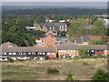
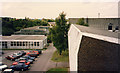
View from Woodcock Hill
Academy Court and Footbridge at Elstree & Borehamwood Station in centre. Byron Avenue towards front of picture. The buildings in the middle, going away from Byron Avenue towards Academy Court, are on the site of the former Fire Research Station which moved to the Building Research Establishment at Garston in 1993. Taken September 2004.
Image: © Andy Frary
Taken: 12 Sep 2004
0.11 miles
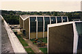
9
The Fire Research Station (12)
A view from the North end of the site looking South-West. The brick wall running left to right of centre is the back of a number of specialist store rooms where hazardous items were kept away from other buildings. On the right of the picture is the original 1935 Furnace Building with a smaller 1970s extension added on.
This area now forms part of Shelley Close and Shakespeare Drive.
Image: © John Webb
Taken: Unknown
0.11 miles
10
The Fire Research Station (5)
Looking towards the North end of the site. Nearest building on the right is the end of the Hydraulics Laboratory. On the left, going away from the camera, a single storey office/small lab building, the roof just visible of the old 'Lecture Theatre', then over the grid line into TQ1996 is the workshop and the original 1935 'Appliance Building'. The site road from the far end of the carpark onwards is roughly the line of the present Coleridge Way.
In the far distance is Elstree and Borehamwood railway station - the footbridge is just visible.
Image: © John Webb
Taken: Unknown
0.11 miles