IMAGES TAKEN NEAR TO
Hawthorn Close, ABBOTS LANGLEY, WD5 0SR
Introduction
This page details the photographs taken nearby to Hawthorn Close, WD5 0SR by members of the Geograph project.
The Geograph project started in 2005 with the aim of publishing, organising and preserving representative images for every square kilometre of Great Britain, Ireland and the Isle of Man.

There are currently over 7.5m images from over14,400 individuals and you can help contribute to the project by visiting https://www.geograph.org.uk
Image Map
Images are licensed for reuse under creativecommons.org/licenses/by-sa/2.0
Notes
- Clicking on the map will re-center to the selected point.
- The higher the marker number, the further away the image location is from the centre of the postcode.
Image Listing (5 Images Found)
Images are licensed for reuse under creativecommons.org/licenses/by-sa/2.0
Image
Details
Distance
1
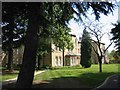
Leavesden Court, Woodside
These buildings were the front face of the hospital
Image: © Jack Hill
Taken: 15 Aug 2005
0.14 miles
2
The junction of College Road and Tibbs Hill Road
Image: © David Howard
Taken: 19 Sep 2012
0.20 miles
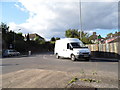
3
South Way at the junction of Langley Lane, Woodside
Image: © David Howard
Taken: 19 Sep 2012
0.21 miles
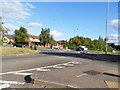
4
Roundabout on College Road, Abbots Langley
Image: © David Howard
Taken: 19 Sep 2012
0.24 miles
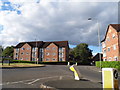
5
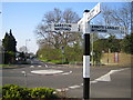
Woodside: High Road & Horseshoe Lane junction
This well cared-for old signpost stands at the centre of the universe apparently, on the north side of the junction of High Road (ahead), Horseshoe Lane (to the left), College Road (to the right), and Woodside Road (behind). The far board points to Leavesden ½. The photo shows one of the two mini-roundabouts here, the other one is to the right.
The High Road here is the boundary between the Watford Borough Council area to the left and the Three Rivers District Council area to the right.
Image: © Nigel Cox
Taken: 9 Apr 2007
0.25 miles