IMAGES TAKEN NEAR TO
Hempstead Road, KINGS LANGLEY, WD4 8QG
Introduction
This page details the photographs taken nearby to Hempstead Road, WD4 8QG by members of the Geograph project.
The Geograph project started in 2005 with the aim of publishing, organising and preserving representative images for every square kilometre of Great Britain, Ireland and the Isle of Man.

There are currently over 7.5m images from over14,400 individuals and you can help contribute to the project by visiting https://www.geograph.org.uk
Image Map
Images are licensed for reuse under creativecommons.org/licenses/by-sa/2.0
Notes
- Clicking on the map will re-center to the selected point.
- The higher the marker number, the further away the image location is from the centre of the postcode.
Image Listing (32 Images Found)
Images are licensed for reuse under creativecommons.org/licenses/by-sa/2.0
Image
Details
Distance
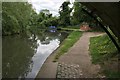
2
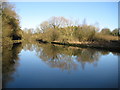
Grand Union Canal near Hunton Bridge
The canal is very broad at this location.
Image: © Nigel Cox
Taken: 1 Jan 2010
0.07 miles
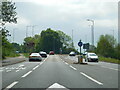
3
West side, Hunton bridge roundabout (A41)
Image: © Peter Whatley
Taken: 19 Jun 2012
0.08 miles
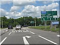
4
A41 bottleneck, Hunton Bridge
A few hundred yards of this important trunk route remain a single carriageway between Hunton Bridge and the M25 roundabout. A classic case of lack of joined-up planning. The petrol station in the distance was remarkably cheap by local standards!
Image: © Peter Whatley
Taken: 19 Jun 2012
0.08 miles
6
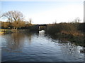
Grand Union Canal: M25 Motorway spur bridge
This totally functional concrete bridge, which is devoid of any architectural merit whatsoever, carries the M25 Motorway spur road over the canal and to and from the Hunton Bridge roundabout.
Image: © Nigel Cox
Taken: 1 Jan 2010
0.13 miles
7
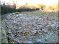
Grand Union Canal: Silted up bay
The towpath side of the canal makes a large semi-circular bay just to the north of Image The bay appears to have silted up over time and although boat-users would probably pass it by without realising its presence, it makes a large deviation away from the canal for towpath walkers and cyclists. It appears to be too large for a canal narrowboat turning bay, so what was its purpose?
The only clue comes from the older editions of the large scale Ordnance Survey mapping. The 1883 version shows a rectangular building described as a mill (plus some other but indecipherable words), in the centre of the bay. Later editions refer to the building, which has long since been demolished, as a pumping house.
On the first day of the new decade the shadow of the motorway embankment above it had prevented any sun from reaching most of it and the water and reeds remain resolutely frozen hard.
Image: © Nigel Cox
Taken: 1 Jan 2010
0.13 miles
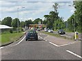
8
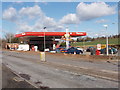
Filling station, by Hunton Bridge Interchange, Watford
On the A41 just north of the interchange to a branch of the M25. View from the south.
Image: © David Hawgood
Taken: 28 Feb 2006
0.14 miles
9
M25 slip road at Hunton Bridge roundabout
Image: © Peter Whatley
Taken: 19 Jun 2012
0.14 miles
10
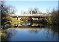
Grand Union Canal: A41 Watford Road bridge
There has been a bridge crossing of the canal here since pre-motor traffic days, as it appears on the 1871 edition of the Ordnance Survey large scale map.
Image: © Nigel Cox
Taken: 1 Jan 2010
0.15 miles