IMAGES TAKEN NEAR TO
Cherry Hill, RICKMANSWORTH, WD3 4JT
Introduction
This page details the photographs taken nearby to Cherry Hill, WD3 4JT by members of the Geograph project.
The Geograph project started in 2005 with the aim of publishing, organising and preserving representative images for every square kilometre of Great Britain, Ireland and the Isle of Man.

There are currently over 7.5m images from over14,400 individuals and you can help contribute to the project by visiting https://www.geograph.org.uk
Image Map
Images are licensed for reuse under creativecommons.org/licenses/by-sa/2.0
Notes
- Clicking on the map will re-center to the selected point.
- The higher the marker number, the further away the image location is from the centre of the postcode.
Image Listing (4 Images Found)
Images are licensed for reuse under creativecommons.org/licenses/by-sa/2.0
Image
Details
Distance
1
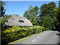
Thatched cottage on Troutstream Way
The River Chess has split into two branches here and this is between the two. The bridge over the northern of the two branches is just ahead under the trees.
Image: © Marathon
Taken: 18 Sep 2019
0.15 miles
2
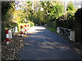
Loudwater: Troutstream Way
The red and white posts are in place to protect two bridges that carry Troutstream Way over two braids of the River Chess.
Image: © Nigel Cox
Taken: 2 Nov 2007
0.19 miles
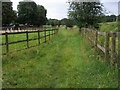
3

Sarratt Lane
Within the Loudwater 30 mph zone, but yet with country on the left, although there are houses behind the hedge to the right.
Image: © Robin Webster
Taken: 25 Jan 2015
0.23 miles
4
Chess Valley Walk
Chess Valley Walk heading to Troutstream Way
Image: © Shaun Ferguson
Taken: 18 Jul 2008
0.24 miles