IMAGES TAKEN NEAR TO
Farriers Way, WATFORD, WD25 9BX
Introduction
This page details the photographs taken nearby to Farriers Way, WD25 9BX by members of the Geograph project.
The Geograph project started in 2005 with the aim of publishing, organising and preserving representative images for every square kilometre of Great Britain, Ireland and the Isle of Man.

There are currently over 7.5m images from over14,400 individuals and you can help contribute to the project by visiting https://www.geograph.org.uk
Image Map
Images are licensed for reuse under creativecommons.org/licenses/by-sa/2.0
Notes
- Clicking on the map will re-center to the selected point.
- The higher the marker number, the further away the image location is from the centre of the postcode.
Image Listing (13 Images Found)
Images are licensed for reuse under creativecommons.org/licenses/by-sa/2.0
Image
Details
Distance
1
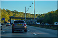
Three Rivers : M1 Motorway
The M1 Motorway between Junction 6 (Waterdale) and Junction 5 (Berrygrove).
Image: © Lewis Clarke
Taken: 3 Oct 2018
0.06 miles
2
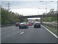
M1 northbound passes under Bucknalls Lane
Image: © Colin Pyle
Taken: 19 Apr 2015
0.13 miles
4
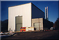
The Building Research Station (2)
The 'Burn Hall', built on the site of the original site boiler house. Built to accommodate large-scale fire tests uninfluenced by wind and weather, the building includes an extract and filtering system to minimise unpleasant emissions to the atmosphere.
This photograph was taken on the occasion of the first commissioning test when the local fire crew from Garston fire station attended to give assistance.
Image: © John Webb
Taken: Unknown
0.15 miles
5
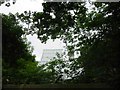
Building Research Establishment Garston
As you see the security is tight but I did get access once to see the experimental house.
Image: © Jack Hill
Taken: 3 Jul 2005
0.15 miles
6
B.R.E. at Garston
They have allowed the trees to grow as the neighbours don't like the "modern" design. The house has a front elevation of sloping glass to catch the sun.
Image: © Jack Hill
Taken: 3 Jul 2005
0.16 miles
7
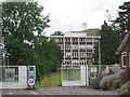
The Building Research Station (4)
The front of "Bucknells", the original Victorian mansion which became the Administrative centre for BRE when it moved to Garston. Taken on a rather gloomy and damp day, alas.
Image: © John Webb
Taken: 8 May 2014
0.20 miles
8
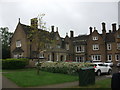
The Building Research Station (1)
The original stable block built to accompany 'Bucknalls', the large house built on this site in 1855.
Image: © John Webb
Taken: Unknown
0.20 miles
9
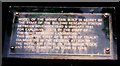
Model Dam Information, Building Research
Near the dam pictured in Image is a short explanatory information board, shown here.
This simple sign has since been replaced - see Image
Image: © John Webb
Taken: Unknown
0.23 miles
10
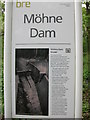
The Building Research Station (5)
An updated notice giving more of the history of the model dam built during WW2. See Image for a picture of the dam taken on the same date.
Image: © John Webb
Taken: 8 May 2014
0.24 miles