IMAGES TAKEN NEAR TO
Kingswood Road, WATFORD, WD25 0EQ
Introduction
This page details the photographs taken nearby to Kingswood Road, WD25 0EQ by members of the Geograph project.
The Geograph project started in 2005 with the aim of publishing, organising and preserving representative images for every square kilometre of Great Britain, Ireland and the Isle of Man.

There are currently over 7.5m images from over14,400 individuals and you can help contribute to the project by visiting https://www.geograph.org.uk
Image Map
Images are licensed for reuse under creativecommons.org/licenses/by-sa/2.0
Notes
- Clicking on the map will re-center to the selected point.
- The higher the marker number, the further away the image location is from the centre of the postcode.
Image Listing (13 Images Found)
Images are licensed for reuse under creativecommons.org/licenses/by-sa/2.0
Image
Details
Distance
1
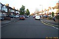
Watford: Kingswood Estate
A view looking westwards down Kingswood Road from its junction with Moss Road, this estate of 1920s - 1940s housing covers the southern third of this grid square.
Image: © Nigel Cox
Taken: 30 Oct 2005
0.11 miles
3
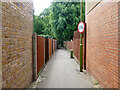
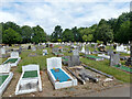
Footpath from Fern Way to St Albans Road
Also to a small play area and a way in to North Watford Cemetery.
Image: © Robin Webster
Taken: 10 Jun 2015
0.16 miles
4
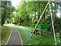
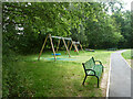
Play area by North Watford Cemetery
The cemetery is off to the right.
Image: © Robin Webster
Taken: 10 Jun 2015
0.18 miles
5
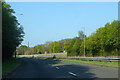
A405 Kingsway North Orbital Road
Orbiting anticlockwise.
Image: © Robin Webster
Taken: 2 May 2021
0.18 miles
8
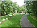
Play area by North Watford Cemetery
The cemetery is off to the left.
Image: © Robin Webster
Taken: 10 Jun 2015
0.20 miles
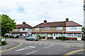
9
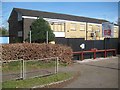
Watford: Former North Watford Police Station
This is the 1950s built police station on the A405 North Orbital Road photographed about 18 months after its closure by Hertfordshire Constabulary in November 2013.
The building was subsequently demolished and the site redeveloped for housing. Please see Image] for a view of the completed development in September 2020.
Image: © Nigel Cox
Taken: 12 Apr 2015
0.22 miles
10
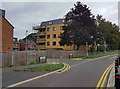
Watford: Humberstone Close
This is the housing development on the site of Image
The main buff brick block is not uniformly rectangular, but actually in the shape of a flattened octagon.
Image: © Nigel Cox
Taken: 3 Sep 2020
0.22 miles