IMAGES TAKEN NEAR TO
Leggatts Close, WATFORD, WD24 5NG
Introduction
This page details the photographs taken nearby to Leggatts Close, WD24 5NG by members of the Geograph project.
The Geograph project started in 2005 with the aim of publishing, organising and preserving representative images for every square kilometre of Great Britain, Ireland and the Isle of Man.

There are currently over 7.5m images from over14,400 individuals and you can help contribute to the project by visiting https://www.geograph.org.uk
Image Map (Loading...)


Getting Data...Please wait
Leaflet Map data © OpenStreetMap
Images are licensed for reuse under creativecommons.org/licenses/by-sa/2.0
Notes
- Clicking on the map will re-center to the selected point.
- The higher the marker number, the further away the image location is from the centre of the postcode.
Image Listing (14 Images Found)
Images are licensed for reuse under creativecommons.org/licenses/by-sa/2.0
Image
Details
Distance
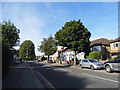
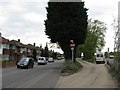
2
Leggats Way
Suburban housing by the side of the A41, North Western Avenue.
Image: © M J Richardson
Taken: 26 Apr 2010
0.04 miles
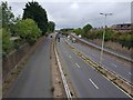
4
North Western Avenue, looking east
The A41 near North Watford, looking towards London.
Image: © M J Richardson
Taken: 26 Apr 2010
0.07 miles
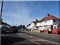
5
Bus-only access to North Western Avenue
From Leggats Way to the A41.
Image: © M J Richardson
Taken: 26 Apr 2010
0.09 miles
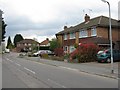
6
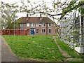
Hertfordshire County Council buildings
A sign indicates the ownership, and 'keep out'. The map indicates that it is a college - not clear whether the buildings are still in use.
Image: © M J Richardson
Taken: 26 Apr 2010
0.11 miles
7
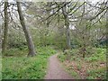
Harebreaks Wood
A local nature reserve in North Watford.
Image: © M J Richardson
Taken: 26 Apr 2010
0.12 miles
8
North Western Avenue
The A41, looking west at its junction with Kingsway North Orbital Road [A405].
Image: © M J Richardson
Taken: 26 Apr 2010
0.12 miles
9
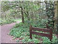
Harebreaks Wood Local Nature Reserve
Image: © M J Richardson
Taken: 26 Apr 2010
0.13 miles
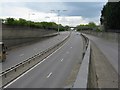
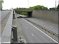
10
Watford: A41 North Western Avenue
This is the view looking west from the footbridge that connects Leggatts Way and the present-day Leggatts Rise. When it was first built this section of the current A41 was the A500, and was also known then as Leggatts Rise.
The slip road on the left leads up to the elevated roundabout junction with the A405 North Orbital Road. The 1939 large scale OS map shows that when these two roads were first built, the A405 Kingsway North Orbital Road, as it then was, formed a T-junction with the A500.
Image: © Nigel Cox
Taken: 3 Sep 2020
0.14 miles