IMAGES TAKEN NEAR TO
Upper Tail, WATFORD, WD19 5DF
Introduction
This page details the photographs taken nearby to Upper Tail, WD19 5DF by members of the Geograph project.
The Geograph project started in 2005 with the aim of publishing, organising and preserving representative images for every square kilometre of Great Britain, Ireland and the Isle of Man.

There are currently over 7.5m images from over14,400 individuals and you can help contribute to the project by visiting https://www.geograph.org.uk
Image Map
Images are licensed for reuse under creativecommons.org/licenses/by-sa/2.0
Notes
- Clicking on the map will re-center to the selected point.
- The higher the marker number, the further away the image location is from the centre of the postcode.
Image Listing (21 Images Found)
Images are licensed for reuse under creativecommons.org/licenses/by-sa/2.0
Image
Details
Distance
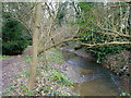
1
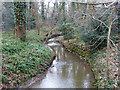
Hartsbourne Stream
Looking downstream.
Image: © Robin Webster
Taken: 23 Feb 2013
0.07 miles
3
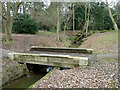
Bridge over Hartsbourne Stream
In the landscaped woodland called 'Woodwalks' along the stream, formerly part of the grounds of the old Carpenders Park house, now within the bounds of Carpenders Park Lawn Cemetery. Beyond is the overflow from a pond.
Image: © Robin Webster
Taken: 23 Feb 2013
0.08 miles
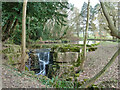
4
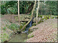
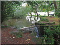
Weir on Hartsbourne Stream
In the landscaped woodland called 'Woodwalks' along the stream, formerly part of the grounds of the old Carpenders Park house, now within the bounds of Carpenders Park Lawn Cemetery. This is the overflow from a pond.
Image: © Robin Webster
Taken: 23 Feb 2013
0.09 miles
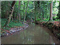
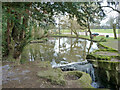
5
Pond on Hartsbourne Stream
In the landscaped area along the stream called 'Woodwalks', formerly part of the grounds of the old Carpenders Park house, now within the bounds of Carpenders Park Lawn Cemetery.
Image: © Robin Webster
Taken: 23 Feb 2013
0.09 miles
6
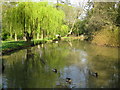
Carpenders Park Lawn Cemetery: The Lake
The lake appears to have originally been a man-made fish pond in the grounds of the original Carpenders Park estate, created by damming up the Hartsbourne Stream.
Image: © Nigel Cox
Taken: 21 Apr 2009
0.11 miles
7
Pond on Hartsbourne Stream
In the landscaped area along the stream called 'Woodwalks', formerly part of the grounds of the old Carpenders Park house, now within the bounds of Carpenders Park Lawn Cemetery.
Image: © Robin Webster
Taken: 23 Feb 2013
0.11 miles
10
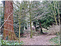
Woodland path
In the landscaped area called 'Woodwalks', formerly part of the grounds of the old Carpenders Park house, now within the bounds of Carpenders Park Lawn Cemetery.
Image: © Robin Webster
Taken: 23 Feb 2013
0.12 miles