IMAGES TAKEN NEAR TO
Penrose Avenue, WATFORD, WD19 5AD
Introduction
This page details the photographs taken nearby to Penrose Avenue, WD19 5AD by members of the Geograph project.
The Geograph project started in 2005 with the aim of publishing, organising and preserving representative images for every square kilometre of Great Britain, Ireland and the Isle of Man.

There are currently over 7.5m images from over14,400 individuals and you can help contribute to the project by visiting https://www.geograph.org.uk
Image Map
Images are licensed for reuse under creativecommons.org/licenses/by-sa/2.0
Notes
- Clicking on the map will re-center to the selected point.
- The higher the marker number, the further away the image location is from the centre of the postcode.
Image Listing (7 Images Found)
Images are licensed for reuse under creativecommons.org/licenses/by-sa/2.0
Image
Details
Distance
1
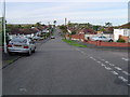
Carpenders Park: Greenfield Avenue
Viewed looking westwards in the housing estate where the properties are predominantly bungalows.
Image: © Nigel Cox
Taken: 12 Nov 2005
0.07 miles
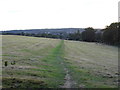
2
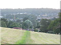
View across Carpenders Park from Merry Hill
Image: © David Howard
Taken: 13 Sep 2012
0.08 miles
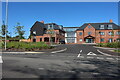
4

Path to The Mead, Carpenders Park
Designated a public footpath, and signed accordingly, this route cuts through between the houses on Carpenders Avenue and The Mead at the bottom.
Image: © Stephen McKay
Taken: 5 Apr 2022
0.20 miles
5
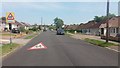
School Ahead
School Ahead on Carpenders Avenue heading to Oxhey Lane
Image: © Shaun Ferguson
Taken: 15 May 2019
0.20 miles
6

Carpenders Avenue, Carpenders Park
Carpenders Park is very much an outer London suburb although it is situated outside the Greater London area. The development took place either side of the Second World War and the housing is typical of its time including a significant number of bungalows. The name is derived from a local manor house that was demolished in 1960 but has perhaps survived because it was given to the nearby railway station.
Image: © Stephen McKay
Taken: 5 Apr 2022
0.22 miles
7
Merry Hill looking towards Carpenders Park
Image: © David Howard
Taken: 13 Sep 2012
0.24 miles