IMAGES TAKEN NEAR TO
Epsom Road, WATFORD, WD18 8AQ
Introduction
This page details the photographs taken nearby to Epsom Road, WD18 8AQ by members of the Geograph project.
The Geograph project started in 2005 with the aim of publishing, organising and preserving representative images for every square kilometre of Great Britain, Ireland and the Isle of Man.

There are currently over 7.5m images from over14,400 individuals and you can help contribute to the project by visiting https://www.geograph.org.uk
Image Map
Images are licensed for reuse under creativecommons.org/licenses/by-sa/2.0
Notes
- Clicking on the map will re-center to the selected point.
- The higher the marker number, the further away the image location is from the centre of the postcode.
Image Listing (42 Images Found)
Images are licensed for reuse under creativecommons.org/licenses/by-sa/2.0
Image
Details
Distance
1
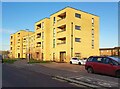
Watford: Pearl Court, Epsom Road
Pearl Court is one of three apartment blocks on Epsom Road, off Tolpits Lane. It has 22 one- and two-bedroom homes for affordable rent, which new residents first moved into in April 2019.
Image: © Nigel Cox
Taken: 26 Nov 2020
0.04 miles
2
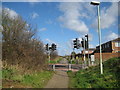
Watford: A4145 Tolpits Lane pedestrian crossing
A view taken looking from the Ebury Way towards Holywell across Tolpits Lane.
Image: © Nigel Cox
Taken: 21 Mar 2008
0.04 miles
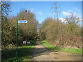
3
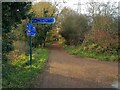
Watford: Ebury Way
This is a same view repeat of this image Image] from 2008. I am pleased to say that the sign with the wildly over-optimistic distance to Cassiobury Park has now been replaced with one that is more realistic!
Image: © Nigel Cox
Taken: 26 Nov 2020
0.08 miles

5
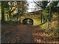
Watford: Ebury Way, Tolpits Lane bridge
Ebury Way viewed looking west towards the A4145 Tolpits Lane bridge and then to Rickmansworth. Ebury Way follows the trackbed of the long dismantled railway line from Watford to Rickmansworth. Opened in 1862, it was shortly afterwards taken over by the London & North Western Railway, but was an early victim of the post-war Nationalization of the railways, closing to passenger traffic in 1952.
Image: © Nigel Cox
Taken: 26 Nov 2020
0.09 miles
6
Watford: Ebury Way
Ebury Way viewed looking west towards the A4145 Tolpits Lane bridge and then to Rickmansworth. Ebury Way follows the trackbed of the long dismantled railway line from Watford to Rickmansworth. Opened in 1862, it was shortly afterwards taken over by the London & North Western Railway, but was an early victim of the post-war Nationalization of the railways, closing to passenger traffic in 1952. It is now a popular route for cyclists. The blue sign has a wildly overoptimistic distance of ¼ mile to Cassiobury Park and Watford Met Line Station. The very nearest point in the park is at least 1 mile away and the station at least a ¼ mile beyond that!
Image: © Nigel Cox
Taken: 21 Mar 2008
0.12 miles
7

A4145 Tolpits Lane, Holywell, Watford
Looking towards Chenies Way at the junction with Chaffinch Lane
Image: © Geographer
Taken: 12 Apr 2014
0.15 miles
8
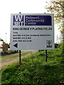
Holywell Community Centre sign
At King George V Playing Fields off the A4145 Tolpits Lane
Image: © Geographer
Taken: 12 Apr 2014
0.17 miles
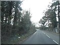
10

A4145 Tolpits Lane, Holywell, Watford
At the junction with Chaffinch Lane & entrance to King George V Playing Fields
Image: © Geographer
Taken: 12 Apr 2014
0.17 miles