IMAGES TAKEN NEAR TO
Queens Road, WATFORD, WD17 2QN
Introduction
This page details the photographs taken nearby to Queens Road, WD17 2QN by members of the Geograph project.
The Geograph project started in 2005 with the aim of publishing, organising and preserving representative images for every square kilometre of Great Britain, Ireland and the Isle of Man.

There are currently over 7.5m images from over14,400 individuals and you can help contribute to the project by visiting https://www.geograph.org.uk
Image Map (Loading...)


Getting Data...Please wait
Leaflet Map data © OpenStreetMap
Images are licensed for reuse under creativecommons.org/licenses/by-sa/2.0
Notes
- Clicking on the map will re-center to the selected point.
- The higher the marker number, the further away the image location is from the centre of the postcode.
Image Listing (152 Images Found)
Images are licensed for reuse under creativecommons.org/licenses/by-sa/2.0
Image
Details
Distance
1
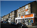
Watford: Queen's Road
The western side of Queen's Road has these distinctive mid-Victorian three storey houses, the lower floors of which have been converted into shops. To the right is the shop of J Simble and Sons http://www.simbles.com/site/ who have been here selling ironmongery and tools for many years.
Image: © Nigel Cox
Taken: 23 May 2010
0.01 miles
3
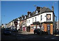
Watford: Queen's Road: The Broadway
The pub on the corner is now The Amber Rooms, formerly the Mad George and originally Blakes Free House. A user's comment on another website referring to his experience during its Mad George incarnation was that it was the sort of place where you wiped your feet on the way out.
Image: © Nigel Cox
Taken: 23 May 2010
0.05 miles
4
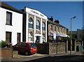
Watford: Former Beulah Chapel, Loates Lane
The building was constructed in 1869 as a Beulah Chapel, and has had several occupiers since. Today it in use as a nursery.
There is a rather fine grouping of Victorian terraced houses beyond.
Image: © Nigel Cox
Taken: 23 May 2010
0.06 miles
5
Watford: Ebury Road
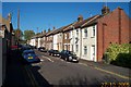
A fine terrace of Victorian houses, with front doors opening on to the street.
Image: © Nigel Cox
Taken: 27 Oct 2005
0.08 miles
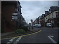
6
Queens Road, Watford
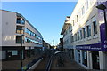
This pedestrian area is connected to the main High Street by the subway shown.
Image: © David Howard
Taken: 20 Aug 2020
0.08 miles
8
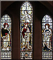
St John the Evangelist, Watford - Stained glass window
Image: © John Salmon
Taken: 20 Jan 2016
0.09 miles
9
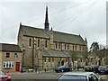
St John's church, Sutton Road, Watford
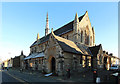
In full, Saint John the Apostle and Evangelist, an Anglo-Catholic church. A late Victorian grade II listed building.
Image: © Robin Webster
Taken: 10 Mar 2013
0.09 miles
10
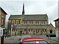
St John's church, Sutton Road, Watford
In full, Saint John the Apostle and Evangelist, an Anglo-Catholic church. A late Victorian grade II listed building.
Image: © Robin Webster
Taken: 10 Mar 2013
0.09 miles