IMAGES TAKEN NEAR TO
Brown Street, WIDNES, WA8 0RE
Introduction
This page details the photographs taken nearby to Brown Street, WA8 0RE by members of the Geograph project.
The Geograph project started in 2005 with the aim of publishing, organising and preserving representative images for every square kilometre of Great Britain, Ireland and the Isle of Man.

There are currently over 7.5m images from over14,400 individuals and you can help contribute to the project by visiting https://www.geograph.org.uk
Image Map
Images are licensed for reuse under creativecommons.org/licenses/by-sa/2.0
Notes
- Clicking on the map will re-center to the selected point.
- The higher the marker number, the further away the image location is from the centre of the postcode.
Image Listing (20 Images Found)
Images are licensed for reuse under creativecommons.org/licenses/by-sa/2.0
Image
Details
Distance
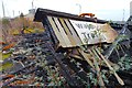
1

Pallet fire, Widnes
A factory building at a pallet recycling unit burns while firefighters attempt to control and extinguish the flames.
Image: © Matt Harrop
Taken: 16 Jul 2015
0.11 miles
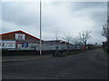
2
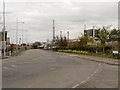
Moss Bank Road, Widnes Waterfront
The Widnes Waterfront Regeneration Programme was developed to transform over 300 acres of former chemical works on the north bank of the River Mersey into a mixed use area, providing a place for businesses to locate and for people to enjoy. The programme began in 2002 using European and UK Government funding and has since attracted further private sector investment.
Image: © David Dixon
Taken: 23 Apr 2013
0.12 miles
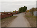
4
Widnes Waterfront, Moss Bank Road
The Widnes Waterfront Regeneration Programme was developed to transform over 300 acres of former chemical works on the north bank of the River Mersey into a mixed use area, providing a place for businesses to locate and for people to enjoy. The programme began in 2002 using European and UK Government funding and has since attracted further private sector investment.
Image: © David Dixon
Taken: 23 Apr 2013
0.14 miles
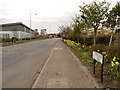
7
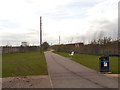
Greenway, Widnes Waterfront
The Widnes Waterfront Regeneration Programme was developed to transform over 300 acres of former chemical works on the north bank of the River Mersey into a mixed use area, providing a place for businesses to locate and for people to enjoy. The programme began in 2002 using European and UK Government funding and has since attracted further private sector investment.
Image: © David Dixon
Taken: 23 Apr 2013
0.17 miles
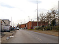
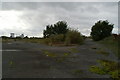
8
Weighbridge Training Centre after fire, Tanhouse Lane, Widnes
Tanhouse Lane station was demolished after 1965 and its site was developed with a weighbridge and car park which in turn had gone out of use by the 1990s. In 2014 the station site was a derelict piece of land awaiting development and the Weighbridge Training Station has recently been destroyed by fire.
Image: © Matt Harrop
Taken: 5 Feb 2015
0.17 miles
9
The Before picture, 2008
Hopefully someone will return to this spot and take an After shot of the site after it has been redeveloped as part of Halton's Waterfront oroject for the area.
Image: © David Long
Taken: 30 Sep 2008
0.18 miles
10
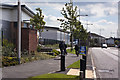
Tan House Lane
The Widnes Waterfront Regeneration Programme was developed to transform over 300 acres of former chemical works on the north bank of the River Mersey into a mixed use area, providing a place for businesses to locate and for people to enjoy. The programme began in 2002 using European and UK Government funding and has since attracted further private sector investment.
Image: © David Dixon
Taken: 23 Apr 2013
0.19 miles