IMAGES TAKEN NEAR TO
Sugar Lane, FRODSHAM, WA6 9EB
Introduction
This page details the photographs taken nearby to Sugar Lane, WA6 9EB by members of the Geograph project.
The Geograph project started in 2005 with the aim of publishing, organising and preserving representative images for every square kilometre of Great Britain, Ireland and the Isle of Man.

There are currently over 7.5m images from over14,400 individuals and you can help contribute to the project by visiting https://www.geograph.org.uk
Image Map
Images are licensed for reuse under creativecommons.org/licenses/by-sa/2.0
Notes
- Clicking on the map will re-center to the selected point.
- The higher the marker number, the further away the image location is from the centre of the postcode.
Image Listing (27 Images Found)
Images are licensed for reuse under creativecommons.org/licenses/by-sa/2.0
Image
Details
Distance
6
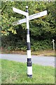
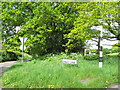
Old Direction Sign - Signpost by Manley Road
Pawn finial - 3 arms; Cheshire New CCC octagonal by the B5393, in parish of Manley (Vale Royal District), Manley Road junction with Pingot Lane.
Surveyed
Milestone Society National ID: CH_SJ5172B
Image: © Milestone Society
Taken: Unknown
0.07 miles
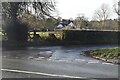
9
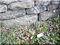
Cut Mark #2: Manley Road, Manley
OS Cut Mark into sandstone wall next to a postbox on Manley Road, Manley. Number B11336 on the Benchmark Database, see http://www.bench-marks.org.uk/bm37715
Image: © VBForever
Taken: 22 Apr 2011
0.09 miles