IMAGES TAKEN NEAR TO
Bramhall Street, WARRINGTON, WA5 1AT
Introduction
This page details the photographs taken nearby to Bramhall Street, WA5 1AT by members of the Geograph project.
The Geograph project started in 2005 with the aim of publishing, organising and preserving representative images for every square kilometre of Great Britain, Ireland and the Isle of Man.

There are currently over 7.5m images from over14,400 individuals and you can help contribute to the project by visiting https://www.geograph.org.uk
Image Map
Images are licensed for reuse under creativecommons.org/licenses/by-sa/2.0
Notes
- Clicking on the map will re-center to the selected point.
- The higher the marker number, the further away the image location is from the centre of the postcode.
Image Listing (50 Images Found)
Images are licensed for reuse under creativecommons.org/licenses/by-sa/2.0
Image
Details
Distance
1
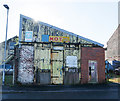
M.O.T. Testing Centre, Bramhall Street, Warrington
Gloriously distressed old shed with a wedge of cheese on top.
Image: © Matt Harrop
Taken: 19 Aug 2016
0.06 miles
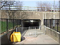
3
Littons Mill Crossing
Level crossing on the former LNWR railway from Ditton Junction to Timperley (for Stockport). This section is still used to bring coal to Fiddler's Ferry power station, but the line is dismantled beyond Warrington.
Image: © Alan Murray-Rust
Taken: 6 Oct 2008
0.08 miles
4
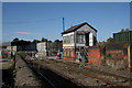
Litton's Mill Crossing
A fine London and North Western Railway signal box still adorns the crossing, but the gates are now manually operated. The mill referred to may or may not be the same as Faircloughs Mill which supports the Eye Image
Image: © Alan Murray-Rust
Taken: 6 Oct 2008
0.09 miles
6
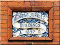
Diamond Jubilee Buildings (datestone)
Judging by the date (1897), I assume that the top line should read "Diamond Jubilee" and that the buildings (Image]) were named for Queen Victoria's Diamond Jubilee in that year.
Image: © David Dixon
Taken: 27 Jul 2012
0.10 miles
7
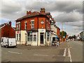
Diamond Jubilee Buildings, Liverpool Road, Warrington
The buildings, at the corner of Wellfield Street and Liverpool Road, were erected in 1897, the year of Queen Victoria's Diamond Jubilee (Image]).
Image: © David Dixon
Taken: 27 Jul 2012
0.10 miles
8
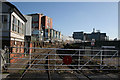
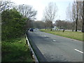
Sankey Roundabout
A large roundabout on the A57 on the western side of Warrington town centre. It is large enough to make it impossible to capture all of it in one image.
Image: © Bill Boaden
Taken: 22 May 2017
0.10 miles
9
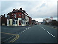
Old Liverpool Road/Wellfield Street junction
Image: © Colin Pyle
Taken: 21 Jan 2012
0.11 miles
10
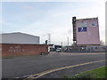
Quay Fold and the Warrington Eye
Quay Fold is the road opposite with the parked vans in it. The Warrington Eye is a mural by local artist Anthony Turk on a building that was a former grain store on Bank Quay.
Image: © Chris Allen
Taken: 29 Dec 2018
0.14 miles