IMAGES TAKEN NEAR TO
Helmsley Close, WARRINGTON, WA5 0GF
Introduction
This page details the photographs taken nearby to Helmsley Close, WA5 0GF by members of the Geograph project.
The Geograph project started in 2005 with the aim of publishing, organising and preserving representative images for every square kilometre of Great Britain, Ireland and the Isle of Man.

There are currently over 7.5m images from over14,400 individuals and you can help contribute to the project by visiting https://www.geograph.org.uk
Image Map
Images are licensed for reuse under creativecommons.org/licenses/by-sa/2.0
Notes
- Clicking on the map will re-center to the selected point.
- The higher the marker number, the further away the image location is from the centre of the postcode.
Image Listing (20 Images Found)
Images are licensed for reuse under creativecommons.org/licenses/by-sa/2.0
Image
Details
Distance
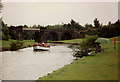
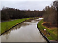
1
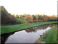
Historic boating
The ST HELEN swings to turn below the former Bewsey swing bridge. This bridge gave the nearest access to Warrington (to the right) for men based at the US Base at RAF Burtonwood, and a large number of accommodation huts were built in the area around Bewsey Old Hall, just to the left of the bridge. This section of the canal is a well-known coarse fishery.
Image: © David Long
Taken: Unknown
0.15 miles
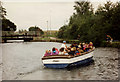
4
Historic boating
The ST HELEN north of the 7 arches viaduct. The square section of the platform over the canal is markedly different from the other arches. Further upstream Stephenson's 9 arch Earlestown Viaduct had to be built 70' high to allow the high-master Mersey sailing flats to pass beneath. It is assumed that here there was a moveable section over the canal to allow the same facility, but no details of it seem to exist.
Image: © David Long
Taken: Unknown
0.17 miles
5
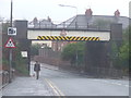
Lovely Lane, Warrington
A railway bridge across Lovely Lane, Warrington. Warning signs indicate that the maximum safe height for vehicles is 15 feet and 3 inches.
Notice that the road dips slightly as it passes under the bridge. This suggests that the road may have been lowered slightly, to increase the clearance for vehicles passing beneath the bridge.
Image: © Malc McDonald
Taken: 8 Oct 2011
0.17 miles
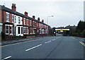
6
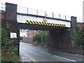
Railway bridge near Warrington
A bridge carrying a railway across Lovely Lane in Warrington.
Image: © Malc McDonald
Taken: 8 Oct 2011
0.17 miles
7
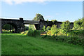
Railway Bridge over St Helens (Sankey) Canal
The Sankey Viaduct in Sankey Valley Park crosses both the canal and Sankey Brook. Known as the "Seven Arches", although it consisted of seven arches and one iron-girder span over the canal itself, this 1873 viaduct carries the Liverpool to Manchester via Warrington railway. It is thought that the span across the canal may have originally had a lifting mechanism, to allow the masts of the sailing barges to pass through.
Image: © David Dixon
Taken: 6 Jul 2019
0.18 miles
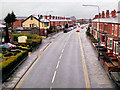
9
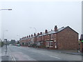
Lovely Lane, Warrington
Brick-built housing on Lovely Lane, Warrington
Image: © Malc McDonald
Taken: 8 Oct 2011
0.19 miles