IMAGES TAKEN NEAR TO
Cartridge Lane, WARRINGTON, WA4 4SH
Introduction
This page details the photographs taken nearby to Cartridge Lane, WA4 4SH by members of the Geograph project.
The Geograph project started in 2005 with the aim of publishing, organising and preserving representative images for every square kilometre of Great Britain, Ireland and the Isle of Man.

There are currently over 7.5m images from over14,400 individuals and you can help contribute to the project by visiting https://www.geograph.org.uk
Image Map
Images are licensed for reuse under creativecommons.org/licenses/by-sa/2.0
Notes
- Clicking on the map will re-center to the selected point.
- The higher the marker number, the further away the image location is from the centre of the postcode.
Image Listing (8 Images Found)
Images are licensed for reuse under creativecommons.org/licenses/by-sa/2.0
Image
Details
Distance
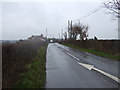
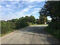
1
Cottages on Cartridge Lane
Now by-passed by a new road to the M6/A50/M56 junction from Appleton Trading Estate
Image: © David Long
Taken: 3 Mar 2006
0.07 miles
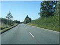
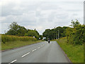
3
Grappenhall Lane
Unusual for a country road with a national Speed Limit - a really good straight section of road on the B5356 (Grappenhall Lane) between Lymm (J21 of the M6 ahead) and Appleton Thorn.
Image: © Mike Lyne
Taken: 1 Feb 2012
0.12 miles