IMAGES TAKEN NEAR TO
Barleycastle Lane, WARRINGTON, WA4 4RF
Introduction
This page details the photographs taken nearby to Barleycastle Lane, WA4 4RF by members of the Geograph project.
The Geograph project started in 2005 with the aim of publishing, organising and preserving representative images for every square kilometre of Great Britain, Ireland and the Isle of Man.

There are currently over 7.5m images from over14,400 individuals and you can help contribute to the project by visiting https://www.geograph.org.uk
Image Map
Images are licensed for reuse under creativecommons.org/licenses/by-sa/2.0
Notes
- Clicking on the map will re-center to the selected point.
- The higher the marker number, the further away the image location is from the centre of the postcode.
Image Listing (10 Images Found)
Images are licensed for reuse under creativecommons.org/licenses/by-sa/2.0
Image
Details
Distance
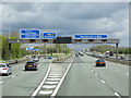
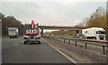
2
Junction 9 on M56 east bound
Junction with M6
Image: © John Firth
Taken: 9 May 2012
0.12 miles
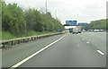
4
Off to the north
Traffic leaves the M56 motorway, in lane for either the M6 northbound or the A50. Much of the traffic leaving here will be heading for the M62 eastbound at Croft intersection, using the extremely busy section of M6 across Thelwall viaduct.
Image: © Peter Whatley
Taken: 18 Jan 2011
0.16 miles
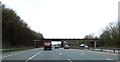
5
M56, Stretton
The westbound M56, passing under the bridge near Stretton Distribution Park.
Image: © David Dixon
Taken: 9 Nov 2010
0.16 miles
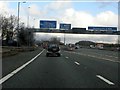
7
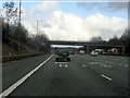
M56 Motorway approaching Barleycastle Lane bridge
Traffic for the M6 has a dedicated lane for each direction.
Image: © Peter Whatley
Taken: 18 Jan 2011
0.17 miles
8
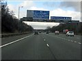
M56 Motorway at junction 9
The eastbound M56 expands to five lanes approaching the M6/A50 intersection.
Image: © Peter Whatley
Taken: 18 Jan 2011
0.18 miles
9
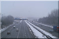
Clearway
The first real snow of winter is soon cleared off the M56/ M6 junction at Stretton
Image: © David Long
Taken: 4 Mar 2006
0.19 miles
10
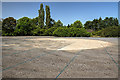
WWII Cheshire: RNAS Stretton, Compass Swing Base
A circular concrete hard standing on which aircraft were positioned. Used to accurately adjust aircraft magnetic compasses. Currently the site is being prepared for use as a car park, the lines of blue rope being used to mark out the parking lanes.
START: Image
Image: © Mike Searle
Taken: 28 Jun 2019
0.23 miles