IMAGES TAKEN NEAR TO
Wilmslow Crescent, WARRINGTON, WA4 2JE
Introduction
This page details the photographs taken nearby to Wilmslow Crescent, WA4 2JE by members of the Geograph project.
The Geograph project started in 2005 with the aim of publishing, organising and preserving representative images for every square kilometre of Great Britain, Ireland and the Isle of Man.

There are currently over 7.5m images from over14,400 individuals and you can help contribute to the project by visiting https://www.geograph.org.uk
Image Map
Images are licensed for reuse under creativecommons.org/licenses/by-sa/2.0
Notes
- Clicking on the map will re-center to the selected point.
- The higher the marker number, the further away the image location is from the centre of the postcode.
Image Listing (42 Images Found)
Images are licensed for reuse under creativecommons.org/licenses/by-sa/2.0
Image
Details
Distance
1
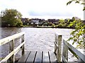
Thelwall Ferry on Manchester Ship Canal
View from jetty on north bank of canal
Image: © Raymond Knapman
Taken: 16 Oct 2008
0.08 miles
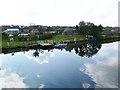
3
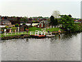
Manchester Ship Canal, Thelwall Ferry
Known locally as The Penny Ferry but officially called The Thelwall Ferry, has provided a crossing of the Ship Canal since its opening in 1894. The canal's emergence created many new trade opportunities but it created problems getting across Warrington. Where there was an established right of way, the ship canal company was obliged to keep it open. Usually this meant a road bridge or viaduct but in Thelwall, where the canal cut through a farm and footpath, they opted instead to provide a small ferryboat service and, for the past 120 years, a small rowing boat has been taking passengers from one side of the Manchester Ship Canal to the other in order to maintain the long-established public right of way.
http://allthingswarrington.net/Places/Places/thelwallpennyferry.html#.VzodlJDmqHs - All Things Warrington
Image: © David Dixon
Taken: 11 May 2016
0.09 miles
4
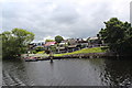
Manchester Ship Canal - Thelwall Ferry
Navigational beacon number 303 can also be seen.
Image: © Alan Heardman
Taken: 13 Jul 2014
0.09 miles
5
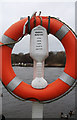
Thelwall Ferry
Seen through a life ring at the picnic area on the southern bank of the Manchester Ship Canal.
Image: © michael ely
Taken: 11 Jan 2015
0.09 miles
6
Thelwall Ferry
From Woolston to Thelwall & vice-versa, across Manchester Ship Canal; 12p single or 25p for the day. http://www.grappenhallandthelwallpc.org.uk/index.htm
Image: © Mike Faherty
Taken: 18 Sep 2011
0.09 miles
7

Thelwall Ferry
Down a small track from the Post Office and a strange contrast to the nearby Thelwall Viaduct on the M6.
Image: © Howard Selina
Taken: Unknown
0.10 miles
8
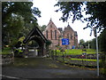
Lychgate and churchyard, All Saints' Church, Thelwall
Image: © Richard Vince
Taken: 12 Sep 2015
0.10 miles
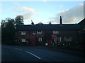
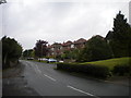
10
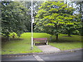
Sodden bus stop, Thelwall New Road, Thelwall
The bus stop for services towards Lymm and Altrincham is provided with a bench but not, alas, a shelter, which would have been very useful on this wet day.
Image: © Richard Vince
Taken: 12 Sep 2015
0.10 miles