IMAGES TAKEN NEAR TO
Beech Hill, Town Lane, KNUTSFORD, WA16 7HT
Introduction
This page details the photographs taken nearby to Beech Hill, Town Lane, WA16 7HT by members of the Geograph project.
The Geograph project started in 2005 with the aim of publishing, organising and preserving representative images for every square kilometre of Great Britain, Ireland and the Isle of Man.

There are currently over 7.5m images from over14,400 individuals and you can help contribute to the project by visiting https://www.geograph.org.uk
Image Map
Images are licensed for reuse under creativecommons.org/licenses/by-sa/2.0
Notes
- Clicking on the map will re-center to the selected point.
- The higher the marker number, the further away the image location is from the centre of the postcode.
Image Listing (13 Images Found)
Images are licensed for reuse under creativecommons.org/licenses/by-sa/2.0
Image
Details
Distance
1
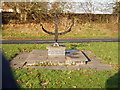
Sundial
Located at junction of Mill Lane & Town Lane Mobberley (Time approx 1.20pm!!)
Image: © Ian Warburton
Taken: 20 Nov 2005
0.04 miles

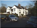
4
The Bull's Head, Mobberley
The Bull's Head dates from 1812. It is tucked away down Mill Lane opposite another pub, The Roebuck, that has been closed for a few years. There are so many pubs because Mill Lane used to be the main road through Mobberley before a bypass was built.
Image: © Steve Whalley
Taken: 5 Sep 2015
0.08 miles
5
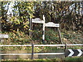
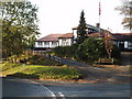
Old road sign at junction of Church Lane & Town Lane , Mobberley
Image: © Ian Warburton
Taken: 20 Nov 2005
0.18 miles
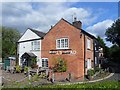
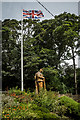
6
The Victory Hall , Mobberley
A popular Village Hall built in 1921 (At a cost of £4500!)
Image: © Ian Warburton
Taken: 20 Nov 2005
0.18 miles
7
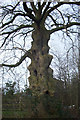
Unusual tree off Damson Lane, Mobberley
Extremely unusual trunk formation.
Image: © Roger Gittins
Taken: 6 Jan 2004
0.19 miles
9
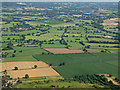
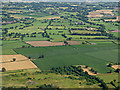
Farmland near Mobberley from the air
Seen shortly after take-off from runway 23L at Manchester Airport. Mobberley nature reserve is at the bottom of the photo.
Image: © Thomas Nugent
Taken: 17 Jul 2017
0.21 miles
10
Farmland near Mobberley from the air
Seen shortly after take-off from runway 23L at Manchester Airport. Mobberley nature reserve is at the bottom of the photo.
Image: © Thomas Nugent
Taken: 17 Jul 2017
0.21 miles