IMAGES TAKEN NEAR TO
The Copse, ALTRINCHAM, WA15 0RU
Introduction
This page details the photographs taken nearby to The Copse, WA15 0RU by members of the Geograph project.
The Geograph project started in 2005 with the aim of publishing, organising and preserving representative images for every square kilometre of Great Britain, Ireland and the Isle of Man.

There are currently over 7.5m images from over14,400 individuals and you can help contribute to the project by visiting https://www.geograph.org.uk
Image Map
Images are licensed for reuse under creativecommons.org/licenses/by-sa/2.0
Notes
- Clicking on the map will re-center to the selected point.
- The higher the marker number, the further away the image location is from the centre of the postcode.
Image Listing (65 Images Found)
Images are licensed for reuse under creativecommons.org/licenses/by-sa/2.0
Image
Details
Distance
1
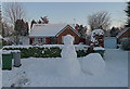
Winter arrives in Hale Barns
An unusual sight after 10 years of mild winters. Many young children may never before have been able to build a snowman.
Image: © Anthony O'Neil
Taken: 8 Jan 2010
0.06 miles
2
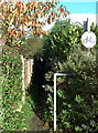
Public footpath - no cycling
Joins Ravenwood Drive to Winmarith Drive but is just part of an old right-of-way used by people walking from Brooks Drive, or Hale Road, to Chapel Lane, across intervening farmland. There were still crops of oats and barley here in the 1950s and considerable excitement amongst local children when the big combine harvesters were at work. Expansion of housing estates around Hale Barns, and the growth of Ringway airport, saw the end of large scale farming in the vicinity.
Image: © Anthony O'Neil
Taken: 9 Nov 2013
0.13 miles
3
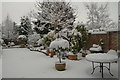
The morning after the night before - Hale Barns, Cheshire
No one expected to awake to this. The garden table registered six inches of virgin snow overnight.
Image: © Anthony O'Neil
Taken: 5 Jan 2010
0.14 miles
4
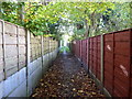
Enclosed footpath from Winmarith Drive
It seems unlikely that the current residents here realise that this path is all that remains of the right-of-way, across open farmland, from Hale Road to Warburton Green. The 1950s building boom in Hale Barns obliterated most of the meadows, copses and fields that surrounded it before the War. There is a (1954) watercolour sketch of the meadow - belonging to Prospect House - which once bordered the brown fence (formerly iron railings) to the right of the photo. Just beyond these railings was a stand of massive beech trees, with a rookery. The meadow was ankle deep in daisies, buttercups, clover and rough grass. Several ponies grazed there, and the nearby pond attracted dragonflies in the summer months. What a change!
Image: © Anthony O'Neil
Taken: 9 Nov 2013
0.14 miles
5
Unexpected history
The owners of these houses and gardens in Winmarith Drive may not know that it was once the site of two conjoined ponds, located between the weeping willow and the boundary of Prospect Drive, beyond. These were about 2 metres deep and roughly 70 metres by 10 metres in surface area. They can be seen on 1940s plans of Hale Barns. A buried culvert pipe - fed by run-off from adjacent fields - kept them topped up, the water being unable to escape the underlying clay. One presumes the developers laid a concrete raft over the drained land before constructing the housing foundations. Perhaps the 'spring' is still there but diverted into the main sewers.
Image: © Anthony O'Neil
Taken: 9 Nov 2013
0.16 miles
9

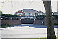
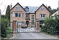
Detached house
456, Hale Road, Hale Barns: characteristic of the newer properties which have been built in the vicinity in recent years.
Image: © Anthony O'Neil
Taken: 30 Aug 2023
0.16 miles
10
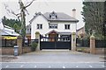
Houses of Hale Barns (19)
Hale Road
Image: © Anthony O'Neil
Taken: 31 Mar 2020
0.17 miles