IMAGES TAKEN NEAR TO
Longsides Road, ALTRINCHAM, WA15 0HT
Introduction
This page details the photographs taken nearby to Longsides Road, WA15 0HT by members of the Geograph project.
The Geograph project started in 2005 with the aim of publishing, organising and preserving representative images for every square kilometre of Great Britain, Ireland and the Isle of Man.

There are currently over 7.5m images from over14,400 individuals and you can help contribute to the project by visiting https://www.geograph.org.uk
Image Map
Images are licensed for reuse under creativecommons.org/licenses/by-sa/2.0
Notes
- Clicking on the map will re-center to the selected point.
- The higher the marker number, the further away the image location is from the centre of the postcode.
Image Listing (59 Images Found)
Images are licensed for reuse under creativecommons.org/licenses/by-sa/2.0
Image
Details
Distance

2
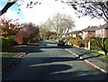
Ravenwood Drive, Hale Barns
Farmland in the 1950s but now part of an extensive estate. A November day but as warm and sunny as early September!
Image: © Anthony O'Neil
Taken: 9 Nov 2013
0.13 miles
3
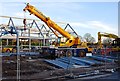
Hale Barns reconstructed
Heavy plant at work on the site of the new shopping centre.
Image: © Anthony O'Neil
Taken: 7 Mar 2014
0.14 miles
4
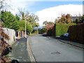
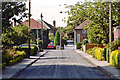
Winmarith Drive, Hale Barns
Approaching the junction with Hale Road. The drive takes its name from a large, pre-war villa which stood in grounds to the right of the photograph. 'Winmarith' is shown on the 1940 local, large-scale plan but, in the following decades, was demolished to make way for the present incumbent - a block of luxury apartments called "The Greens" - which was not an improvement, aesthetically, over its predecessor.
Image: © Anthony O'Neil
Taken: 9 Nov 2013
0.14 miles
5
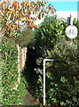
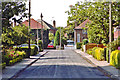
Public footpath - no cycling
Joins Ravenwood Drive to Winmarith Drive but is just part of an old right-of-way used by people walking from Brooks Drive, or Hale Road, to Chapel Lane, across intervening farmland. There were still crops of oats and barley here in the 1950s and considerable excitement amongst local children when the big combine harvesters were at work. Expansion of housing estates around Hale Barns, and the growth of Ringway airport, saw the end of large scale farming in the vicinity.
Image: © Anthony O'Neil
Taken: 9 Nov 2013
0.16 miles
8
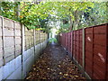
Enclosed footpath from Winmarith Drive
It seems unlikely that the current residents here realise that this path is all that remains of the right-of-way, across open farmland, from Hale Road to Warburton Green. The 1950s building boom in Hale Barns obliterated most of the meadows, copses and fields that surrounded it before the War. There is a (1954) watercolour sketch of the meadow - belonging to Prospect House - which once bordered the brown fence (formerly iron railings) to the right of the photo. Just beyond these railings was a stand of massive beech trees, with a rookery. The meadow was ankle deep in daisies, buttercups, clover and rough grass. Several ponies grazed there, and the nearby pond attracted dragonflies in the summer months. What a change!
Image: © Anthony O'Neil
Taken: 9 Nov 2013
0.18 miles
9
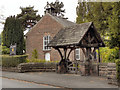
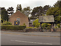
Hale Chapel
The Unitarian Chapel on Chapel Lane, Hale Barns was built in 1723 and was originally a Presbyterian meeting house. It is a Grade II listed building.
Image: © David Dixon
Taken: 16 Sep 2011
0.18 miles
10
Hale Chapel
The Unitarian Chapel on Chapel Lane, Hale Barns, was built in 1723 and was originally a Presbyterian meeting house. It is a Grade II listed building.
Image: © David Dixon
Taken: 16 Sep 2011
0.18 miles