IMAGES TAKEN NEAR TO
Denholme Road, LONDON, W9 3HT
Introduction
This page details the photographs taken nearby to Denholme Road, W9 3HT by members of the Geograph project.
The Geograph project started in 2005 with the aim of publishing, organising and preserving representative images for every square kilometre of Great Britain, Ireland and the Isle of Man.

There are currently over 7.5m images from over14,400 individuals and you can help contribute to the project by visiting https://www.geograph.org.uk
Image Map
Images are licensed for reuse under creativecommons.org/licenses/by-sa/2.0
Notes
- Clicking on the map will re-center to the selected point.
- The higher the marker number, the further away the image location is from the centre of the postcode.
Image Listing (75 Images Found)
Images are licensed for reuse under creativecommons.org/licenses/by-sa/2.0
Image
Details
Distance
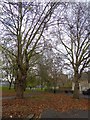
1
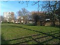
Recreation ground between Malvern Road and Carlton Vale
Image: © David Martin
Taken: 4 Mar 2013
0.08 miles
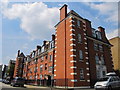
2
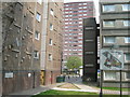
South Kilburn Estate
This picture was taken on Malvern Road. "Welcome to Dickens House", says the sign on the left. Austen House is through the walkway, Blake Court is to the right of the walkway. These flats, and many nearby, will be demolished soon for a much needed but controversial regeneration project. There was recently a police raid on this estate which recovered several guns and a significant quantity of crack cocaine, cash and other items. Links of interest are below..
http://society.guardian.co.uk/urbandesign/story/0,,870922,00.html
http://www.brent.gov.uk/filmloc.nsf/0/EC01CDBAC43C9E098025718700360098?OpenDocument
http://www.kilburntimes.co.uk/content/camden/kilburntimes/news/story.aspx?brand=KLBTOnline&category=news&tBrand=northlondon24&tCategory=newsklbt&itemid=WeED18%20Apr%202007%2014%3A58%3A22%3A777
Image: © Danny P Robinson
Taken: 29 Apr 2007
0.09 miles
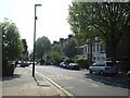
3
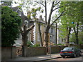
Malvern Road, NW6
The tree lined street and the large houses may look attractive, but this is the view from the front Image
Image: © Danny P Robinson
Taken: 29 Apr 2007
0.09 miles
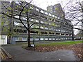
8
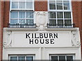
Detail above an entrance to Kilburn House, Malvern Place, NW6
See Image
Image: © Mike Quinn
Taken: 4 Jul 2011
0.12 miles
9
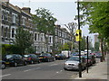
Fernhead Road, W9
At the junction of Croxley Road, looking towards Queens Park. Tall 19th century houses like these are the predominant feature in this area. Many will now have been converted to flats. The yellow sign is a police warning not to display your valuables indiscreetly as there is a higher than average risk of muggings or thefts from vehicles here. MP3 players and high spec mobile phones are particularly vulnerable.
Image: © Danny P Robinson
Taken: 29 Apr 2007
0.13 miles
10
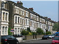
Croxley Road, W9
Picture taken at the junction of Fernhead Road. Tall 19th century houses like these are the predominant feature in this area. Many will now have been converted to flats.
Image: © Danny P Robinson
Taken: 29 Apr 2007
0.13 miles