IMAGES TAKEN NEAR TO
Warwick Avenue, LONDON, W9 2PU
Introduction
This page details the photographs taken nearby to Warwick Avenue, W9 2PU by members of the Geograph project.
The Geograph project started in 2005 with the aim of publishing, organising and preserving representative images for every square kilometre of Great Britain, Ireland and the Isle of Man.

There are currently over 7.5m images from over14,400 individuals and you can help contribute to the project by visiting https://www.geograph.org.uk
Image Map
Images are licensed for reuse under creativecommons.org/licenses/by-sa/2.0
Notes
- Clicking on the map will re-center to the selected point.
- The higher the marker number, the further away the image location is from the centre of the postcode.
Image Listing (284 Images Found)
Images are licensed for reuse under creativecommons.org/licenses/by-sa/2.0
Image
Details
Distance
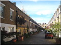
1
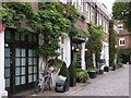
Mews Street in Maida Vale
My favourite mews street in Maida Vale because it's unmodernised and the locals keep it in good condition.
It's called Pindock Mews and is between Castellaine Road and Warwick Avenue.
Image: © John Andrew
Taken: 14 Sep 2008
0.03 miles
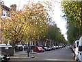
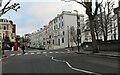
2
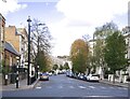
Autumnal colour in Warwick Avenue
This view looks across the crossing of Warwick Avenue and Formosa Street. Warwick Avenue is to the left and Formosa Street is to the right.
Image: © Marathon
Taken: 13 Nov 2013
0.04 miles
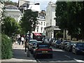
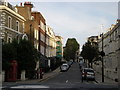
3
Castellain Road, Maida Vale, W9
View north-west from near the junction with Formosa Street.
Image: © Stefan Czapski
Taken: 2 Nov 2021
0.04 miles
6
Shirland Road at the junction of Formosa Street
Image: © David Howard
Taken: 20 Jan 2022
0.05 miles
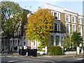
8
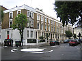
Maida Vale: Formosa Street, W9
This neat terrace of mid-Victorian townhouses is at the northern end of Formosa Street at its junction with Warwick Avenue.
Image: © Nigel Cox
Taken: 19 Aug 2007
0.05 miles
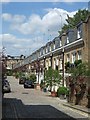
9
Formosa Street, Maida Vale: view north-east
I had a vague memory of Formosa Street, from way back in the last century - as a little stub of a street, going round a sharp bend. So I was surprised - approaching from the bridge over the canal - to find myself in a wide thoroughfare of that same name.
Having walked the length of it, I'd say that there are three distinct stretches. Approaching from the south, you first reach the wide straight bit, sloping down from the canal. Part of that carries a bus route. Then, beyond the junction with Warwick Avenue, the roadway narrows and veers a little to the right (middle distance in the picture). Finally, beyond Castellain Road (and not visible in the picture) there is my 'stub'. The road is narrow and there's a tight bend. The place feels much more enclosed and inhabited - with folk eating at tables set out on the pavement.
Image: © Stefan Czapski
Taken: 2 Nov 2021
0.06 miles
10
Clifton garden centre and Bristol Gardens
This is a view up Bristol Gardens towards the Clifton Garden Centre (the white awning on the right at the top of the street). It is taken from the corner of Shirland Road and Formosa Street (and Bristol Gardens and Blomfield Road, as it's a roundabout with four differently named streets leading off it).
Image: © John Andrew
Taken: 14 Sep 2008
0.06 miles