IMAGES TAKEN NEAR TO
Lauderdale Road, LONDON, W9 1NF
Introduction
This page details the photographs taken nearby to Lauderdale Road, W9 1NF by members of the Geograph project.
The Geograph project started in 2005 with the aim of publishing, organising and preserving representative images for every square kilometre of Great Britain, Ireland and the Isle of Man.

There are currently over 7.5m images from over14,400 individuals and you can help contribute to the project by visiting https://www.geograph.org.uk
Image Map
Images are licensed for reuse under creativecommons.org/licenses/by-sa/2.0
Notes
- Clicking on the map will re-center to the selected point.
- The higher the marker number, the further away the image location is from the centre of the postcode.
Image Listing (119 Images Found)
Images are licensed for reuse under creativecommons.org/licenses/by-sa/2.0
Image
Details
Distance
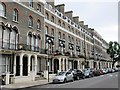
1
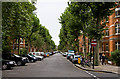
Lauderdale Road
A wide straight road in the Maida Vale area bounded by apartment blocks and Plane trees. The road sees relatively light use and demonstrates one of the solutions to parking issues employed in the area, with bays set almost at right angles to the kerb, reducing the width of the road slightly. An alternative method employed on even wider roads (such as the adjacent Sutherland Avenue) is to create a central reservation of parking bays, effectively turning the road into a dual carriageway!
Image: © Martin Addison
Taken: 25 Aug 2009
0.02 miles
2
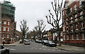
Biddulph Road
As seen from Lauderdale Road.
Image: © David Anstiss
Taken: 8 Mar 2015
0.04 miles
4
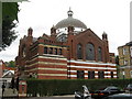
Lauderdale Road Synagogue, Maida Vale
The Maida Vale synagogue, at the junction of Lauderdale Road and Ashworth roads, is called Sha'ar Hashamayim but is referred to as "Lauderdale Road". It is one of three synagogues (the others are in the City of London and Wembley of the Spanish & Portuguese Jews' Congregation (an orthodox Sephardi congregation). The congregation was founded in the City of London over 300 years ago by a community that had escaped the Inquisition to Amsterdam. Some of its members settled in London when Oliver Cromwell set aside laws banning Jews from living in England. The building is Grade II listed.http://www.lauderdaleroadsynagogue.org/html/home.asp
Image: © Richard Rogerson
Taken: 8 Jul 2010
0.09 miles
5
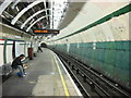
Maida Vale Underground Station
This is the southbound platform undergoing renovation
Image: © Oxyman
Taken: 13 Apr 2007
0.10 miles
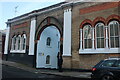
8
Lanark Road looking towards Randolph Avenue
Image: © David Howard
Taken: 25 Jan 2021
0.11 miles
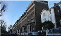
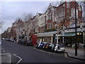
9
Randolph Avenue, W9
The east side, southeast of Image
Image: © Mike Quinn
Taken: 20 Aug 2015
0.12 miles
10
The entrance to Elgin Mews South, Maida Vale
Image: © David Howard
Taken: 25 Jan 2021
0.12 miles