IMAGES TAKEN NEAR TO
Biddulph Road, LONDON, W9 1JB
Introduction
This page details the photographs taken nearby to Biddulph Road, W9 1JB by members of the Geograph project.
The Geograph project started in 2005 with the aim of publishing, organising and preserving representative images for every square kilometre of Great Britain, Ireland and the Isle of Man.

There are currently over 7.5m images from over14,400 individuals and you can help contribute to the project by visiting https://www.geograph.org.uk
Image Map
Images are licensed for reuse under creativecommons.org/licenses/by-sa/2.0
Notes
- Clicking on the map will re-center to the selected point.
- The higher the marker number, the further away the image location is from the centre of the postcode.
Image Listing (106 Images Found)
Images are licensed for reuse under creativecommons.org/licenses/by-sa/2.0
Image
Details
Distance
1
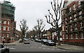
Biddulph Road
As seen from Lauderdale Road.
Image: © David Anstiss
Taken: 8 Mar 2015
0.02 miles
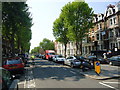
2
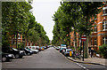
Lauderdale Road
A wide straight road in the Maida Vale area bounded by apartment blocks and Plane trees. The road sees relatively light use and demonstrates one of the solutions to parking issues employed in the area, with bays set almost at right angles to the kerb, reducing the width of the road slightly. An alternative method employed on even wider roads (such as the adjacent Sutherland Avenue) is to create a central reservation of parking bays, effectively turning the road into a dual carriageway!
Image: © Martin Addison
Taken: 25 Aug 2009
0.07 miles
3
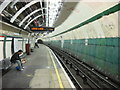
Maida Vale Underground Station
This is the southbound platform undergoing renovation
Image: © Oxyman
Taken: 13 Apr 2007
0.08 miles
6
The entrance to Elgin Mews South, Maida Vale
Image: © David Howard
Taken: 25 Jan 2021
0.11 miles
8
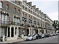
Randolph Avenue, W9
The east side, southeast of Image
Image: © Mike Quinn
Taken: 20 Aug 2015
0.11 miles
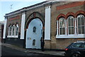
9
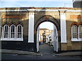
Entrance to Elgin Mews South
This facade is immediately next to Maida Vale Tube which is just to the left out of the picture - see http://www.geograph.org.uk/photo/3747408
Image: © Marathon
Taken: 13 Nov 2013
0.12 miles
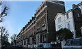
10

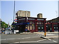
Exterior of Maida Vale Underground station
Originally called the Baker Street & Waterloo Railway, the Bakerloo line was constructed by the Underground Electric Railways Company of London and opened between Baker Street and Lambeth North in 1906. It was extended to Elephant & Castle five months later, on 5th August. The contraction of the name to "Bakerloo" rapidly caught on, and the official name was changed to match in July 1906.
By 1913, the line had been extended from its original northern terminus at Baker Street to the west with interchange stations with the Great Central Railway at Marylebone and the Great Western Railway at Paddington, and a new station at Edgware Road. In 1915 the line was extended to Queen's Park when Maida Vale station was opened.
The station is 'Grade II' listed and in 2009 the station won a National Railway Heritage Award, in the London Regional category, for the successful modernisation of a historic station. This is looking across Randolph Avenue. The building on the extreme right is part of the facade to Elgin Mews South - see http://www.geograph.org.uk/photo/3747322
Image: © Marathon
Taken: 13 Nov 2013
0.12 miles