IMAGES TAKEN NEAR TO
Stratford Road, LONDON, W8 6QF
Introduction
This page details the photographs taken nearby to Stratford Road, W8 6QF by members of the Geograph project.
The Geograph project started in 2005 with the aim of publishing, organising and preserving representative images for every square kilometre of Great Britain, Ireland and the Isle of Man.

There are currently over 7.5m images from over14,400 individuals and you can help contribute to the project by visiting https://www.geograph.org.uk
Image Map
Images are licensed for reuse under creativecommons.org/licenses/by-sa/2.0
Notes
- Clicking on the map will re-center to the selected point.
- The higher the marker number, the further away the image location is from the centre of the postcode.
Image Listing (255 Images Found)
Images are licensed for reuse under creativecommons.org/licenses/by-sa/2.0
Image
Details
Distance
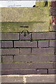
1
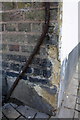
Benchmark on #22 Stratford Road (Radley Mews face)
Ordnance Survey cut mark benchmark described on the Bench Mark Database at http://www.bench-marks.org.uk/bm47264
Image: © Roger Templeman
Taken: 14 Feb 2013
0.02 miles
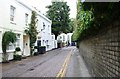
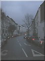
2
Junction of Radley Mews and Stratford Road
There is an OS benchmark Image on the corner of the near house to the right of the rubbish bags.
Image: © Roger Templeman
Taken: 14 Feb 2013
0.02 miles
3
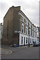
Devonshire Arms, Kensington
The pub is on the corner of the tree-lined Marloes Road (foreground) and Stratford Road, with its parade of shops.
Image: © Derek Harper
Taken: 31 Jul 2009
0.02 miles
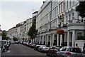
6
Lexham Gardens, W8
In years gone by, this part of Kensington and Earl's Court were notoriously known as "Bedsitland". Now if the houses haven't been converted back to single occupancy use, they're converted into many flats.
Image: © Phillip Perry
Taken: 10 Aug 2010
0.04 miles
7
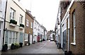
Radley Mews, W8
One of many, many mews(es) around Kensington
Image: © Phillip Perry
Taken: 10 Aug 2010
0.04 miles
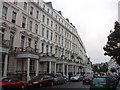
8
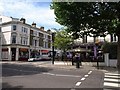
Lexham Gardens, London W8
Take from the junction with Earl's Court Road
Image: © Robin Sones
Taken: 2 Jan 2008
0.05 miles
9
Benchmark on Marloes Road wall near Beatrice Place junction
Ordnance Survey cut mark benchmark described on the Bench Mark Database at http://www.bench-marks.org.uk/bm47268
Image: © Roger Templeman
Taken: 14 Feb 2013
0.06 miles