IMAGES TAKEN NEAR TO
Blacks Road, LONDON, W6 9DT
Introduction
This page details the photographs taken nearby to Blacks Road, W6 9DT by members of the Geograph project.
The Geograph project started in 2005 with the aim of publishing, organising and preserving representative images for every square kilometre of Great Britain, Ireland and the Isle of Man.

There are currently over 7.5m images from over14,400 individuals and you can help contribute to the project by visiting https://www.geograph.org.uk
Image Map
Images are licensed for reuse under creativecommons.org/licenses/by-sa/2.0
Notes
- Clicking on the map will re-center to the selected point.
- The higher the marker number, the further away the image location is from the centre of the postcode.
Image Listing (330 Images Found)
Images are licensed for reuse under creativecommons.org/licenses/by-sa/2.0
Image
Details
Distance
1
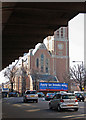
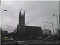
St Paul, Queen Caroline Street, Hammersmith
From under Hammersmith flyover
Image: © John Salmon
Taken: 8 Mar 2011
0.02 miles
2
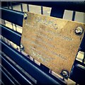
Rik Mayall Bench Hammersmith
In memory of the comedy actor
Image: © Bartolo Creations
Taken: Unknown
0.03 miles
3
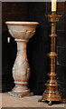
St Paul, Queen Caroline Street, Hammersmith - Font
Image: © John Salmon
Taken: 8 Mar 2011
0.03 miles
6
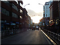
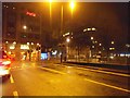
King Street, Hammersmith
Central Hammersmith illuminated by evening sunshine.
Image: © Stephen McKay
Taken: 25 Sep 2015
0.03 miles
8
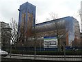
Hammersmith: church-shaped scaffolding
The tarpaulins around the scaffolding on St. Paul's, Hammersmith, are illustrated with the church that they conceal. The real porch can be seen bottom-right of picture, as can the real flagpole top-left.
Image: © Chris Downer
Taken: 20 Jan 2008
0.04 miles
9
Church of St Paul, Hammersmith
The Church of St Paul looks to have very recently been revamped, as the Google Streetview of the location http://www.google.co.uk/maps?f=q&source=s_q&hl=en&geocode=&q=hammersmith&aq=&sll=51.479392,-0.247965&sspn=0.009448,0.030534&ie=UTF8&hq=&hnear=Hammersmith,+Greater+London,+United+Kingdom&ll=51.491538,-0.224791&spn=0.008497,0.061069&z=15&layer=c&cbll=51.491552,-0.224776&panoid=qfNkU6Zvwnm5izreIsf3PQ&cbp=11,311.09,,0,-0.44 shows the church in scaffolding and plastic sheeting. View taken looking southwest from Hammersmith Bridge Road, at its junction with Queen Caroline Street.
Image: © Robert Lamb
Taken: 24 Feb 2011
0.04 miles
10
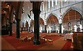
St Paul, Queen Caroline Street, Hammersmith - Interior
Image: © John Salmon
Taken: 8 Mar 2011
0.04 miles