IMAGES TAKEN NEAR TO
Astrop Mews, LONDON, W6 7HR
Introduction
This page details the photographs taken nearby to Astrop Mews, W6 7HR by members of the Geograph project.
The Geograph project started in 2005 with the aim of publishing, organising and preserving representative images for every square kilometre of Great Britain, Ireland and the Isle of Man.

There are currently over 7.5m images from over14,400 individuals and you can help contribute to the project by visiting https://www.geograph.org.uk
Image Map
Images are licensed for reuse under creativecommons.org/licenses/by-sa/2.0
Notes
- Clicking on the map will re-center to the selected point.
- The higher the marker number, the further away the image location is from the centre of the postcode.
Image Listing (116 Images Found)
Images are licensed for reuse under creativecommons.org/licenses/by-sa/2.0
Image
Details
Distance
1
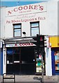
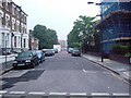
Shepherds Bush
Goldhawk Road is the centre of a gritty, working-class district and lined with traditional shops like this pie and mash outlet adjacent to Goldhawk Road tube station.
Image: © Rosalind Mitchell
Taken: Unknown
0.02 miles
2
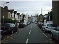
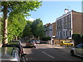
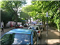
Astrop Terrace, W6
Ok, 3 houses on the left that have been converted to flats
Image: © Phillip Perry
Taken: 17 Nov 2008
0.03 miles
4
Hammersmith Grove W6
At the junction with Benbow Road W6
Image: © Robin Sones
Taken: 19 May 2009
0.04 miles
5
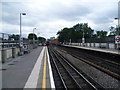
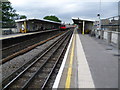
View from Goldhawk Road station towards Hammersmith
The line here was opened in 1864. However, Goldhawk Road station was not opened at this location until 1 April 1914 when the station now known as Shepherd's Bush Market, but then as Shepherd's Bush, was moved from its original location between Uxbridge Road and Goldhawk Road to its present position on the north side of Uxbridge Road. Trains on the Hammersmith & City Line serve the station and now also, in an effort to improve its reliability, the Circle Line. The office blocks at Hammersmith can just be seen in the distance.
Image: © Marathon
Taken: 15 Jun 2011
0.05 miles
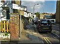
6
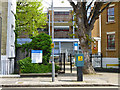
Richford Gate Primary Care Centre
No visitor car parking. Pay here.
Image: © Robin Webster
Taken: 13 May 2012
0.05 miles
7
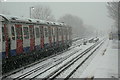
Not so hot on the Hot and Cold
'Hot and Cold' is one of the less opprobrious names for the Hammersmith and City Line (H&C). This is Goldhawk Road Station during the heavy snow on the 18th December 2010. Heavy snow tends to prevent good contact between the electric conductor rail and the pick-up shoes on the trains, and the service on the line was suspended just a few minutes after this picture was taken.
Image: © Alan Murray-Rust
Taken: 18 Dec 2010
0.06 miles
8
Goldhawk Road station
The line here was opened in 1864. However, Goldhawk Road station was not opened at this location until 1 April 1914 when the station now known as Shepherd's Bush Market, but then as Shepherd's Bush, was moved from its original location between Uxbridge Road and Goldhawk Road to its present position on the north side of Uxbridge Road. Trains on the Hammersmith & City Line serve the station and now also, in an effort to improve its reliability, the Circle Line.
Image: © Marathon
Taken: 15 Jun 2011
0.08 miles
9
Hammersmith Grove, W6
Looking towards the junction with Goldhawk Road W12
Image: © Robin Sones
Taken: 19 May 2009
0.08 miles