IMAGES TAKEN NEAR TO
Hammersmith Broadway, LONDON, W6 7AL
Introduction
This page details the photographs taken nearby to Hammersmith Broadway, W6 7AL by members of the Geograph project.
The Geograph project started in 2005 with the aim of publishing, organising and preserving representative images for every square kilometre of Great Britain, Ireland and the Isle of Man.

There are currently over 7.5m images from over14,400 individuals and you can help contribute to the project by visiting https://www.geograph.org.uk
Image Map
Images are licensed for reuse under creativecommons.org/licenses/by-sa/2.0
Notes
- Clicking on the map will re-center to the selected point.
- The higher the marker number, the further away the image location is from the centre of the postcode.
Image Listing (307 Images Found)
Images are licensed for reuse under creativecommons.org/licenses/by-sa/2.0
Image
Details
Distance
1
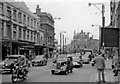
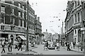
Westward from Hammersmith Broadway, towards Chiswick, 1959
This is before the Hammersmith Flyover was built (11/61). Directly ahead is King Street, leading to Chiswick High Road; to the right of the Charrington Pub is Breadon Road, also (not visible) Brook Green Road (later Shepherds Bush Road. (See Image]). On the left is the entrance to the main Underground Hammersmith station (District and Piccadilly Lines), which is sub-surface here. All these buildings have subsequently been redeveloped.
Image: © Ben Brooksbank
Taken: 26 Sep 1959
0.01 miles
2
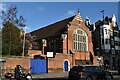
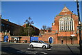
Sacred Heart School
Grade II listed. https://historicengland.org.uk/listing/the-list/list-entry/1192062
Image: © N Chadwick
Taken: 15 Dec 2019
0.01 miles

5
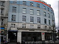
Ladbrokes, Hammersmith Broadway W6
Curving around the junction with Shepherd's Bush Road
Image: © Robin Sones
Taken: 31 Mar 2010
0.02 miles
6

Hammersmith: traffic on the gyratory
Traffic grinds to a halt on the central gyratory of Hammersmith, here seen as the northern end of Queen Caroline Street veers right into Hammersmith Broadway or left into King Street.
Image: © Chris Downer
Taken: 10 Jun 2010
0.02 miles
7
Side entrance to Hammersmith Underground Station, Hammersmith Broadway W6
Image: © Robin Sones
Taken: 31 Mar 2010
0.02 miles
8
Brook Green Road (now Shepherds Bush Road) at Hammersmith Broadway, 1959
View northward, towards Shepherds Bush. Up to the left is the Police Station and the celebrated Palais de Danse. The southbound trolleybus approaching is on either Route 628 (Craven Park - Clapham Junction or 630 (Harrow Road (Scrubs Lane) - West Croydon). (See also Image]).
Image: © Ben Brooksbank
Taken: 26 Sep 1959
0.02 miles
9

Hammersmith Broadway and station entrance
Image: © David Howard
Taken: 19 Jul 2008
0.02 miles
10
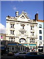
Formerly St Christopher's Inn now called Belushi's
Image: © Alexander P Kapp
Taken: 8 Mar 2009
0.02 miles