IMAGES TAKEN NEAR TO
Railway Arches, Studland Street, LONDON, W6 0LZ
Introduction
This page details the photographs taken nearby to Railway Arches, Studland Street, W6 0LZ by members of the Geograph project.
The Geograph project started in 2005 with the aim of publishing, organising and preserving representative images for every square kilometre of Great Britain, Ireland and the Isle of Man.

There are currently over 7.5m images from over14,400 individuals and you can help contribute to the project by visiting https://www.geograph.org.uk
Image Map
Images are licensed for reuse under creativecommons.org/licenses/by-sa/2.0
Notes
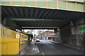
- Clicking on the map will re-center to the selected point.
- The higher the marker number, the further away the image location is from the centre of the postcode.
Image Listing (246 Images Found)
Images are licensed for reuse under creativecommons.org/licenses/by-sa/2.0
Image
Details
Distance
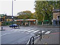
3
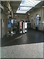
Ravenscourt Park Underground Station ticket office
Image: © Stacey Harris
Taken: 12 Dec 2009
0.02 miles
4
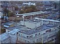
Ravenscourt Park Station
Seen from the top of The Premier Inn on King's Street, Hammersmith
Image: © Neil Theasby
Taken: 8 Oct 2018
0.02 miles
7
Flora Gardens Primary School (entrance), Dalling Road
The main entrance to the school is here in Dalling Road, at the junction with Glenthorne Road. The school was built in 1950 to replace the previous one, which was destroyed by bombing in 1944, during the Second World War. Image
Image: © P L Chadwick
Taken: 24 Oct 2009
0.03 miles
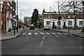
9
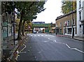
Dalling Road
The streets around here have many closed shops, and others which have been converted into residential use. The area has probably suffered from the opening of large shopping centres fairly nearby, such as King's Mall, and Broadway. The road coming from the left is Glenthorne Road. Ahead is a railway bridge. Image
Image: © P L Chadwick
Taken: 24 Oct 2009
0.03 miles
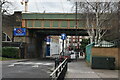
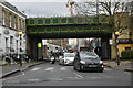
10
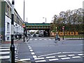
Studland Street
Studland Street is part of the one way system in the centre of Hammersmith. Here it is seen at its junction with Glenthorne Road. Studland Street is crossed by the railway bridge in the centre of the picture.
Image: © P L Chadwick
Taken: 24 Oct 2009
0.03 miles