IMAGES TAKEN NEAR TO
Redmore Road, LONDON, W6 0HZ
Introduction
This page details the photographs taken nearby to Redmore Road, W6 0HZ by members of the Geograph project.
The Geograph project started in 2005 with the aim of publishing, organising and preserving representative images for every square kilometre of Great Britain, Ireland and the Isle of Man.

There are currently over 7.5m images from over14,400 individuals and you can help contribute to the project by visiting https://www.geograph.org.uk
Image Map
Images are licensed for reuse under creativecommons.org/licenses/by-sa/2.0
Notes
- Clicking on the map will re-center to the selected point.
- The higher the marker number, the further away the image location is from the centre of the postcode.
Image Listing (231 Images Found)
Images are licensed for reuse under creativecommons.org/licenses/by-sa/2.0
Image
Details
Distance
1
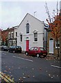
Converted former chapel, Redmore Street
An attractive conversion of a former chapel into residential accommodation.
Image: © P L Chadwick
Taken: 24 Oct 2009
0.03 miles
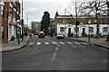
3
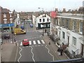
Crossroads in Glenthorne Road
Studland Street leads away from the camera, crossing Glenthorne Road and ending in Redmore Road
Image: © David Smith
Taken: 12 Mar 2011
0.04 miles
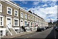
4
Old Shops, Glenthorne Road
The Further block has a date 1907 on the corner face.
The nearer ones look quite a bit older.
Image: © Des Blenkinsopp
Taken: 30 Jul 2015
0.04 miles
5
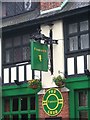
Fiddler's pub sign, 73 Dalling Road
The pub sign for this large pub in Dalling Road, Hammersmith. Image
Image: © P L Chadwick
Taken: 24 Oct 2009
0.04 miles
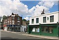
6
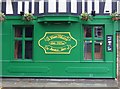
Fiddler's (detail), 73 Dalling Road
The "established 2002" presumably relates to when the present management took over, or perhaps this was the date the pub changed from Tommy Flynns to Fiddler's.
Image: © P L Chadwick
Taken: 24 Oct 2009
0.04 miles
8
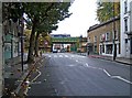
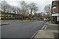
Dalling Road
The streets around here have many closed shops, and others which have been converted into residential use. The area has probably suffered from the opening of large shopping centres fairly nearby, such as King's Mall, and Broadway. The road coming from the left is Glenthorne Road. Ahead is a railway bridge. Image
Image: © P L Chadwick
Taken: 24 Oct 2009
0.05 miles
10
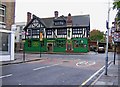
Fiddler's, 73 Dalling Road
This large pub with the garish paintwork was previously known as Tommy Flynns. It was undoubtedly called something else before that. Image; Image
Image: © P L Chadwick
Taken: 24 Oct 2009
0.05 miles