IMAGES TAKEN NEAR TO
Dalling Road, LONDON, W6 0ET
Introduction
This page details the photographs taken nearby to Dalling Road, W6 0ET by members of the Geograph project.
The Geograph project started in 2005 with the aim of publishing, organising and preserving representative images for every square kilometre of Great Britain, Ireland and the Isle of Man.

There are currently over 7.5m images from over14,400 individuals and you can help contribute to the project by visiting https://www.geograph.org.uk
Image Map
Images are licensed for reuse under creativecommons.org/licenses/by-sa/2.0
Notes
- Clicking on the map will re-center to the selected point.
- The higher the marker number, the further away the image location is from the centre of the postcode.
Image Listing (96 Images Found)
Images are licensed for reuse under creativecommons.org/licenses/by-sa/2.0
Image
Details
Distance
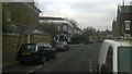
1
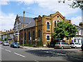
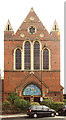
Hammersmith Christian Fellowship
On the corner of Dalling Road and Furber Street, W6. Formerly a Methodist church, the taller building beyond was a Sunday school.
Image: © Robin Webster
Taken: 13 May 2012
0.05 miles
6
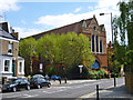
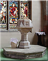
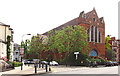
The Church of the Holy Innocents and St. John, Paddenswick Road, W6
A grade II*(star) listed building, 1890s.
Image: © Robin Webster
Taken: 13 May 2012
0.05 miles
7
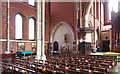
Holy Innocents, Hammersmith - North aisle
Image: © John Salmon
Taken: 7 Jun 2016
0.05 miles
9
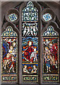
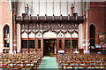
Holy Innocents, Hammersmith - Stained glass window
Image: © John Salmon
Taken: 7 Jun 2016
0.06 miles