IMAGES TAKEN NEAR TO
Cardross Street, LONDON, W6 0DW
Introduction
This page details the photographs taken nearby to Cardross Street, W6 0DW by members of the Geograph project.
The Geograph project started in 2005 with the aim of publishing, organising and preserving representative images for every square kilometre of Great Britain, Ireland and the Isle of Man.

There are currently over 7.5m images from over14,400 individuals and you can help contribute to the project by visiting https://www.geograph.org.uk
Image Map
Images are licensed for reuse under creativecommons.org/licenses/by-sa/2.0
Notes
- Clicking on the map will re-center to the selected point.
- The higher the marker number, the further away the image location is from the centre of the postcode.
Image Listing (82 Images Found)
Images are licensed for reuse under creativecommons.org/licenses/by-sa/2.0
Image
Details
Distance
1
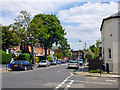
Dalling Road, W6
Looking from the corner of Nasmyth Street.
Image: © Robin Webster
Taken: 13 May 2012
0.03 miles
2
Brackenbury Primary School
The Nursery entrance, formerly the Girls & Infants entrance, according to the inscription over the gate.
Image: © Robin Webster
Taken: 13 May 2012
0.06 miles
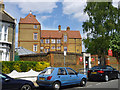
3
Brackenbury Primary School
Formerly Albion Road School, according an inscribed stone high on the front. The school is actually on Dalling Road. The original name is odd, as on a map surveyed in the 1860s (before the school was built) Albion Road was what is now Paddenswick Road, some distance away. Dalling Road was then Farm Lane, there was no Brackenbury Road.
Image: © Robin Webster
Taken: 13 May 2012
0.06 miles
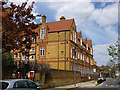
4
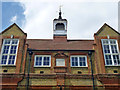
Upper front, Brackenbury Primary School
Formerly Albion Road School, according to the inscribed stone. The school is actually on Dalling Road. The original name is odd, as on a map surveyed in the 1860s (before the school was built) Albion Road was what is now Paddenswick Road, some distance away. Dalling Road was then Farm Lane, there was no Brackenbury Road.
Image: © Robin Webster
Taken: 13 May 2012
0.07 miles
5
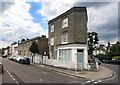
A Very Corner Shop
This unusually shaped former shop, or pub maybe, is on a triangular site at the junction of Dalling And Brackenbury Roads.
Image: © Des Blenkinsopp
Taken: 30 Jul 2015
0.07 miles
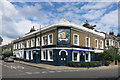
8
The Andover Arms, W6
In Aldensley Road where it meets Cardross Street.
Image: © Phillip Perry
Taken: 28 May 2008
0.13 miles
9
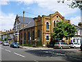
Hammersmith Christian Fellowship
On the corner of Dalling Road and Furber Street, W6. Formerly a Methodist church, the taller building beyond was a Sunday school.
Image: © Robin Webster
Taken: 13 May 2012
0.13 miles
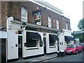
10

Goldhawk Road: 'O'Donoghue's'
Cheerful and apparently thriving pub at the end of Conyngham Road
Image: © Dr Neil Clifton
Taken: 2 Oct 2012
0.14 miles