IMAGES TAKEN NEAR TO
Mattock Lane, LONDON, W5 5BJ
Introduction
This page details the photographs taken nearby to Mattock Lane, W5 5BJ by members of the Geograph project.
The Geograph project started in 2005 with the aim of publishing, organising and preserving representative images for every square kilometre of Great Britain, Ireland and the Isle of Man.

There are currently over 7.5m images from over14,400 individuals and you can help contribute to the project by visiting https://www.geograph.org.uk
Image Map
Images are licensed for reuse under creativecommons.org/licenses/by-sa/2.0
Notes
- Clicking on the map will re-center to the selected point.
- The higher the marker number, the further away the image location is from the centre of the postcode.
Image Listing (165 Images Found)
Images are licensed for reuse under creativecommons.org/licenses/by-sa/2.0
Image
Details
Distance
1
![Ealing houses [8]](https://s3.geograph.org.uk/geophotos/06/36/70/6367071_c642db5f_120x120.jpg)
Ealing houses [8]
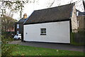
St Raphael's House, number 86 Mattock Lane is early 19th century with a somewhat later wing to the left and a modern wing to the right. Listed, grade II, with details at: https://historicengland.org.uk/listing/the-list/list-entry/1358788
Ealing is one of the seven major towns in the London Borough of Ealing. A rural village until communications with London got better with the improvements to the road to Oxford (later Uxbridge Road) in the 18th century and culminating with the coming of the railway in 1838. Ealing expanded greatly with suburban development during the 19th century and became known as the "Queen of the Suburbs" due to its greenery and because it was halfway between city and country. Ealing became a municipal borough in 1901. Growth continued throughout the 20th century and Ealing became part of a modern London borough in 1965.
Image: © Michael Dibb
Taken: 14 Sep 2019
0.01 miles
2

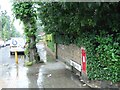
Benchmark on outbuilding of #86 Mattock Lane
Ordnance Survey cut mark benchmark described on the Bench Mark Database at http://www.bench-marks.org.uk/bm71757
Image: © Roger Templeman
Taken: 16 Nov 2015
0.02 miles
3
Outbuilding at St Raphael's House, Mattock Lane
There is an OS benchmark Image on the roadside face of the building near the right hand corner, where the wooden fence abuts
Image: © Roger Templeman
Taken: 16 Nov 2015
0.02 miles
4
![Ealing houses [9]](https://s3.geograph.org.uk/geophotos/06/36/70/6367079_27e954ee_120x120.jpg)
Ealing houses [9]
Number 85 Mattock Lane was built in 2012 and shows some nice detailing.
Ealing is one of the seven major towns in the London Borough of Ealing. A rural village until communications with London got better with the improvements to the road to Oxford (later Uxbridge Road) in the 18th century and culminating with the coming of the railway in 1838. Ealing expanded greatly with suburban development during the 19th century and became known as the "Queen of the Suburbs" due to its greenery and because it was halfway between city and country. Ealing became a municipal borough in 1901. Growth continued throughout the 20th century and Ealing became part of a modern London borough in 1965.
Image: © Michael Dibb
Taken: 14 Sep 2019
0.03 miles
5
![Ealing features [8]](https://s0.geograph.org.uk/geophotos/06/36/79/6367916_dc758b83_120x120.jpg)
Ealing features [8]
From Mattock Lane these fine gates lead into Walpole Park.
The grounds of 18th century Pitzhanger Manor passed into public ownership in the early years of the 20th century. The manor became a library and later a museum, the grounds became Walpole Park - a public park. The park lies mainly to the south-west of the Manor and is laid to grass crossed by axial avenues with lesser paths around the perimeter. The grounds are on the Register of Historic Parks and Gardens, grade II, and there is much history and detail at: https://historicengland.org.uk/listing/the-list/list-entry/1000847
Ealing is one of the seven major towns in the London Borough of Ealing. A rural village until communications with London got better with the improvements to the road to Oxford (later Uxbridge Road) in the 18th century and culminating with the coming of the railway in 1838. Ealing expanded greatly with suburban development during the 19th century and became known as the "Queen of the Suburbs" due to its greenery and because it was halfway between city and country. Ealing became a municipal borough in 1901. Growth continued throughout the 20th century and Ealing became part of a modern London borough in 1965.
Image: © Michael Dibb
Taken: 14 Sep 2019
0.03 miles
6
![Ealing features [9]](https://s2.geograph.org.uk/geophotos/06/36/79/6367918_c54ed361_120x120.jpg)
Ealing features [9]
One of the paths across Walpole Park.
The grounds of 18th century Pitzhanger Manor passed into public ownership in the early years of the 20th century. The manor became a library and later a museum, the grounds became Walpole Park - a public park. The park lies mainly to the south-west of the Manor and is laid to grass crossed by axial avenues with lesser paths around the perimeter. The grounds are on the Register of Historic Parks and Gardens, grade II, and there is much history and detail at: https://historicengland.org.uk/listing/the-list/list-entry/1000847
Ealing is one of the seven major towns in the London Borough of Ealing. A rural village until communications with London got better with the improvements to the road to Oxford (later Uxbridge Road) in the 18th century and culminating with the coming of the railway in 1838. Ealing expanded greatly with suburban development during the 19th century and became known as the "Queen of the Suburbs" due to its greenery and because it was halfway between city and country. Ealing became a municipal borough in 1901. Growth continued throughout the 20th century and Ealing became part of a modern London borough in 1965.
Image: © Michael Dibb
Taken: 14 Sep 2019
0.06 miles
7
Culmington Road
The wallbox for mail is Victorian
Image: © David Smith
Taken: 16 Jun 2011
0.06 miles
8
![Ealing features [7]](https://s3.geograph.org.uk/geophotos/06/36/70/6367063_65f61fb7_120x120.jpg)
Ealing features [7]
A Victorian letter box on the corner of Mattock Lane and Culmington Road.
Ealing is one of the seven major towns in the London Borough of Ealing. A rural village until communications with London got better with the improvements to the road to Oxford (later Uxbridge Road) in the 18th century and culminating with the coming of the railway in 1838. Ealing expanded greatly with suburban development during the 19th century and became known as the "Queen of the Suburbs" due to its greenery and because it was halfway between city and country. Ealing became a municipal borough in 1901. Growth continued throughout the 20th century and Ealing became part of a modern London borough in 1965.
Image: © Michael Dibb
Taken: 14 Sep 2019
0.07 miles
9
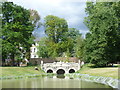
Rustic bridge in Walpole Park
Walpole Park is the grounds of Pitshanger Manor. The park is famous for its trees as each Mayor of Ealing has planted a tree in an avenue.
At the time of writing a substantial restoration is being undertaken of both the house and the park which should be completed in 2017 - see http://en.wikipedia.org/wiki/Pitzhanger_Manor
The houses in this photograph beyond the rustic bridge are in Mattock Lane, along the north side of the park.
Image: © Marathon
Taken: 13 Aug 2014
0.08 miles