IMAGES TAKEN NEAR TO
The Grove, LONDON, W5 5BF
Introduction
This page details the photographs taken nearby to The Grove, W5 5BF by members of the Geograph project.
The Geograph project started in 2005 with the aim of publishing, organising and preserving representative images for every square kilometre of Great Britain, Ireland and the Isle of Man.

There are currently over 7.5m images from over14,400 individuals and you can help contribute to the project by visiting https://www.geograph.org.uk
Image Map (Loading...)


Getting Data...Please wait
Leaflet Map data © OpenStreetMap
Images are licensed for reuse under creativecommons.org/licenses/by-sa/2.0
Notes
- Clicking on the map will re-center to the selected point.
- The higher the marker number, the further away the image location is from the centre of the postcode.
Image Listing (230 Images Found)
Images are licensed for reuse under creativecommons.org/licenses/by-sa/2.0
Image
Details
Distance
1
![Ealing buildings [24]](https://s2.geograph.org.uk/geophotos/06/36/86/6368630_ff67fc25_120x120.jpg)
Ealing buildings [24]
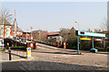
In 2015 a change of use refurbishment on Grove House, Ealing, transformed the building into 100 self contained studios for students. The building was a 1980’s unused former teaching facility, forming part of the University of West London.
Ealing is one of the seven major towns in the London Borough of Ealing. A rural village until communications with London got better with the improvements to the road to Oxford (later Uxbridge Road) in the 18th century and culminating with the coming of the railway in 1838. Ealing expanded greatly with suburban development during the 19th century and became known as the "Queen of the Suburbs" due to its greenery and because it was halfway between city and country. Ealing became a municipal borough in 1901. Growth continued throughout the 20th century and Ealing became part of a modern London borough in 1965.
Image: © Michael Dibb
Taken: 14 Sep 2019
0.02 miles
2
![Ealing houses [28]](https://s0.geograph.org.uk/geophotos/06/36/92/6369244_fbf14043_120x120.jpg)
Ealing houses [28]
Number 6 The Grove is a recently built block of apartments. It is good to see that the building is in keeping with others in the road.
Ealing is one of the seven major towns in the London Borough of Ealing. A rural village until communications with London got better with the improvements to the road to Oxford (later Uxbridge Road) in the 18th century and culminating with the coming of the railway in 1838. Ealing expanded greatly with suburban development during the 19th century and became known as the "Queen of the Suburbs" due to its greenery and because it was halfway between city and country. Ealing became a municipal borough in 1901. Growth continued throughout the 20th century and Ealing became part of a modern London borough in 1965.
Image: © Michael Dibb
Taken: 14 Sep 2019
0.03 miles
3
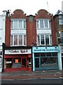
Two shops in High Street Ealing
There is Dutch influence on these two shop facades with plasterwork on the bow windows.
Image: © David Smith
Taken: 13 Jun 2011
0.03 miles
4
![Ealing buildings [25]](https://s0.geograph.org.uk/geophotos/06/36/86/6368640_e1d9c43a_120x120.jpg)
Ealing buildings [25]
This is the Gothic Revival façade of St Saviour CofE primary school. The façade was restored and the entrance brought back into use in 2005. The school was first opened for boys only in 1872 and a school for girls was added in 1886 and they were combined in 1926. The church of St Saviour, built in 1898 which shared the site was destroyed during WWII. The school shares the site with The Clergy House - see Image and Image
Ealing is one of the seven major towns in the London Borough of Ealing. A rural village until communications with London got better with the improvements to the road to Oxford (later Uxbridge Road) in the 18th century and culminating with the coming of the railway in 1838. Ealing expanded greatly with suburban development during the 19th century and became known as the "Queen of the Suburbs" due to its greenery and because it was halfway between city and country. Ealing became a municipal borough in 1901. Growth continued throughout the 20th century and Ealing became part of a modern London borough in 1965.
Image: © Michael Dibb
Taken: 14 Sep 2019
0.03 miles
8
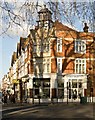
![Ealing buildings [29]](https://s2.geograph.org.uk/geophotos/06/36/92/6369246_cc94da16_120x120.jpg)
Ealing buildings [29]
Now seemingly empty and to let, numbers 22 and 22A The Green are a former chemists shop with accommodation above. Built in 1902 and altered circa 1924. The shop front and the interior chemist shop fittings are complete and almost unaltered from the 1924 re-ordering. Listed, grade II, with details at: https://historicengland.org.uk/listing/the-list/list-entry/1079338
Ealing is one of the seven major towns in the London Borough of Ealing. A rural village until communications with London got better with the improvements to the road to Oxford (later Uxbridge Road) in the 18th century and culminating with the coming of the railway in 1838. Ealing expanded greatly with suburban development during the 19th century and became known as the "Queen of the Suburbs" due to its greenery and because it was halfway between city and country. Ealing became a municipal borough in 1901. Growth continued throughout the 20th century and Ealing became part of a modern London borough in 1965.
Image: © Michael Dibb
Taken: 14 Sep 2019
0.03 miles
9
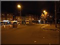
Ealing Broadway Centre
Ramp leading up to the parking levels.
Image: © Martin Addison
Taken: 23 Mar 2012
0.04 miles
10
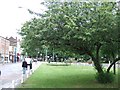
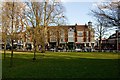
Green space beside Ealing High Street
At the junction of the High Street and Mattock Lane, there is a triangle of grass with trees. The low fences protect it.
Image: © David Smith
Taken: 13 Jun 2011
0.04 miles