IMAGES TAKEN NEAR TO
Alacross Road, LONDON, W5 4HS
Introduction
This page details the photographs taken nearby to Alacross Road, W5 4HS by members of the Geograph project.
The Geograph project started in 2005 with the aim of publishing, organising and preserving representative images for every square kilometre of Great Britain, Ireland and the Isle of Man.

There are currently over 7.5m images from over14,400 individuals and you can help contribute to the project by visiting https://www.geograph.org.uk
Image Map (Loading...)


Getting Data...Please wait
Leaflet Map data © OpenStreetMap
Images are licensed for reuse under creativecommons.org/licenses/by-sa/2.0
Notes
- Clicking on the map will re-center to the selected point.
- The higher the marker number, the further away the image location is from the centre of the postcode.
Image Listing (152 Images Found)
Images are licensed for reuse under creativecommons.org/licenses/by-sa/2.0
Image
Details
Distance
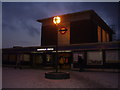
1

Northfields Tube Station
The larger of the 2 stations in the grid square and attached to the depot for the west end of the Piccadilly Line.
Image: © Billy Abbott
Taken: 21 May 2005
0.05 miles
2
Northfields Tube Station
Piccadilly Line station to the west of South Ealing - the two stations are close enough that you can easily see people on one station from the other, and could probably hold a shouted conversation.
Image: © Billy Abbott
Taken: Unknown
0.05 miles
3
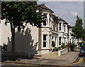
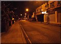
Houses in Alacross Road
View from Dorset Road
Image: © David Hawgood
Taken: 4 Jun 2008
0.07 miles
4
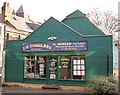
Morgan Specialists
Some traditional British sports cars are still sold by traditional British dealers.
Image: © David Squire
Taken: 2 Dec 2005
0.08 miles
5
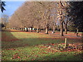
Lammas Park
The stone memorial in the foreground is to Ealing Scouts who fell in both World Wars. A nearby sign reads: The name "Lammas" originated from "Loafmas Day" which was a harvest festival in 1 August. The festival marked the start of the season when villagers were allowed to graze livestock on fields and common lands known as "lammas lands". The grazing continued until Candlemas on 2 February.
Image: © David Squire
Taken: 2 Dec 2005
0.09 miles
6
![Ealing houses [13]](https://s3.geograph.org.uk/geophotos/06/36/79/6367931_78796a57_120x120.jpg)
Ealing houses [13]
Number 15 Church Lane was originally built in the 17th century. Listed, grade II, with details at: https://historicengland.org.uk/listing/the-list/list-entry/1079452
Ealing is one of the seven major towns in the London Borough of Ealing. A rural village until communications with London got better with the improvements to the road to Oxford (later Uxbridge Road) in the 18th century and culminating with the coming of the railway in 1838. Ealing expanded greatly with suburban development during the 19th century and became known as the "Queen of the Suburbs" due to its greenery and because it was halfway between city and country. Ealing became a municipal borough in 1901. Growth continued throughout the 20th century and Ealing became part of a modern London borough in 1965.
Image: © Michael Dibb
Taken: 14 Sep 2019
0.09 miles
7
![Ealing houses [14]](https://s0.geograph.org.uk/geophotos/06/36/79/6367932_a041a598_120x120.jpg)
Ealing houses [14]
This fine brick house at number 1 Church Lane is 18th century and is listed, grade II, with details at: https://historicengland.org.uk/listing/the-list/list-entry/1294378
Ealing is one of the seven major towns in the London Borough of Ealing. A rural village until communications with London got better with the improvements to the road to Oxford (later Uxbridge Road) in the 18th century and culminating with the coming of the railway in 1838. Ealing expanded greatly with suburban development during the 19th century and became known as the "Queen of the Suburbs" due to its greenery and because it was halfway between city and country. Ealing became a municipal borough in 1901. Growth continued throughout the 20th century and Ealing became part of a modern London borough in 1965.
Image: © Michael Dibb
Taken: 14 Sep 2019
0.10 miles
9
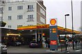
Shell, South Ealing Road, W5
One of those garages that also has a mini-supermarket that's "local".
Image: © Phillip Perry
Taken: 9 Dec 2009
0.10 miles
10
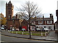
Old Ealing
The historical centre of Ealing is about a mile south of the current centre (which developed at Ealing Broadway after the railway arrived). Notable here are the parish church of St Mary in the background and the small building with red doors which was the old fire station.
Image: © David Squire
Taken: 2 Dec 2005
0.11 miles