IMAGES TAKEN NEAR TO
West Gate, LONDON, W5 1BF
Introduction
This page details the photographs taken nearby to West Gate, W5 1BF by members of the Geograph project.
The Geograph project started in 2005 with the aim of publishing, organising and preserving representative images for every square kilometre of Great Britain, Ireland and the Isle of Man.

There are currently over 7.5m images from over14,400 individuals and you can help contribute to the project by visiting https://www.geograph.org.uk
Image Map
Images are licensed for reuse under creativecommons.org/licenses/by-sa/2.0
Notes
- Clicking on the map will re-center to the selected point.
- The higher the marker number, the further away the image location is from the centre of the postcode.
Image Listing (120 Images Found)
Images are licensed for reuse under creativecommons.org/licenses/by-sa/2.0
Image
Details
Distance
4
![Hanger Hill [7]](https://s2.geograph.org.uk/geophotos/07/41/07/7410758_4dd06340_120x120.jpg)
Hanger Hill [7]
The London Underground Central Line rails leading to and from West Ruislip. Seen from the platform at Hanger Lane station.
Hanger Hill is an area of the London Borough of Ealing. It is famous, or perhaps infamous, for the Hanger Lane gyratory, a complex and busy road junction where the North Circular Road (A406) crosses Western Avenue (A40). The gyratory incorporates Hanger Lane Station on the London Underground.
Image: © Michael Dibb
Taken: 5 Feb 2023
0.04 miles
5
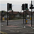
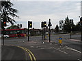
"Cycle Crossing Only" across Hanger Lane North
This is across the busy A4005 dual carriageway to Alperton and Wembley. It has been provided so that cyclists do not have to go via the subways to the tube station, but the green phase is too short for some pedestrians. It crosses from West Gate to Priory Gardens. In the photo the traffic light across the road is green for cyclists.
Image: © David Hawgood
Taken: 21 Aug 2011
0.05 miles
6
Traffic lights amber at cycle crossing on Hanger Lane
The crossing is described in Image
Image: © David Hawgood
Taken: 21 Aug 2011
0.05 miles
7
![Hanger Hill [2]](https://s1.geograph.org.uk/geophotos/07/41/06/7410637_7bdc3d10_120x120.jpg)
Hanger Hill [2]
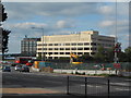
Seen from Hanger Lane, West Gate provides access to a complex of offices and warehouses.
Hanger Hill is an area of the London Borough of Ealing. It is famous, or perhaps infamous, for the Hanger Lane gyratory, a complex and busy road junction where the North Circular Road (A406) crosses Western Avenue (A40). The gyratory incorporates Hanger Lane Station on the London Underground.
Image: © Michael Dibb
Taken: 5 Feb 2023
0.05 miles
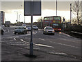
9
Westway before the North Circular junction at Hanger Lane
Image: © David Howard
Taken: 6 Jun 2009
0.06 miles
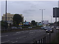
10
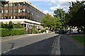
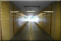
Cycle track from Priory Gardens to cross Hanger Lane
Priory Gardens has a subway under the North Circular to Park Royal, one to the centre of the Hanger Lane Gyratory, and this new cycle track to a "cyclists only" crossing on Hanger Lane.
Image: © David Hawgood
Taken: 21 Aug 2011
0.06 miles