IMAGES TAKEN NEAR TO
Rothschild Road, LONDON, W4 5NS
Introduction
This page details the photographs taken nearby to Rothschild Road, W4 5NS by members of the Geograph project.
The Geograph project started in 2005 with the aim of publishing, organising and preserving representative images for every square kilometre of Great Britain, Ireland and the Isle of Man.

There are currently over 7.5m images from over14,400 individuals and you can help contribute to the project by visiting https://www.geograph.org.uk
Image Map
Images are licensed for reuse under creativecommons.org/licenses/by-sa/2.0
Notes
- Clicking on the map will re-center to the selected point.
- The higher the marker number, the further away the image location is from the centre of the postcode.
Image Listing (252 Images Found)
Images are licensed for reuse under creativecommons.org/licenses/by-sa/2.0
Image
Details
Distance
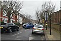
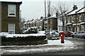
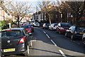
1
Rothschild Road
Looking northeast from Bollo Lane. The effect of the recent snowfall is readily apparent, with cold temperatures preventing the compacted snow from breaking up.
Image: © Alan Murray-Rust
Taken: 19 Dec 2010
0.01 miles
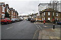
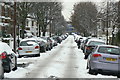
6
Antrobus Road
Part of the Victorian development in the area between Bollo Lane and the original area of Acton Green, on Acton Lane. Although the area is marked on the OS map as Acton Green, the local postal address is Chiswick Park. The pillar box is a rare 'anonymous' example http://www.geograph.org.uk/photo/2205705 .
Image: © Alan Murray-Rust
Taken: 19 Dec 2010
0.06 miles
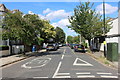
7
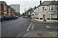
Rothschild Road, looking southwest
This area is known as, and addressed as, Chiswick Park, despite being labelled South Acton on the map. Although clearly laid out as a single estate, there is a considerable variety in house designs which means that lots were clearly allocated piecemeal to various builders.
Image: © Alan Murray-Rust
Taken: 8 Mar 2008
0.06 miles
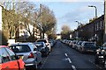
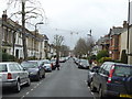
9
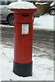
Postbox W4 11 Antrobus Road/Bollo Lane
An example of the rare 'anonymous' pillar box of the 1880s, cast without the royal cipher.
Image: © Alan Murray-Rust
Taken: 19 Dec 2010
0.06 miles