IMAGES TAKEN NEAR TO
Weston Road, LONDON, W4 5NJ
Introduction
This page details the photographs taken nearby to Weston Road, W4 5NJ by members of the Geograph project.
The Geograph project started in 2005 with the aim of publishing, organising and preserving representative images for every square kilometre of Great Britain, Ireland and the Isle of Man.

There are currently over 7.5m images from over14,400 individuals and you can help contribute to the project by visiting https://www.geograph.org.uk
Image Map
Images are licensed for reuse under creativecommons.org/licenses/by-sa/2.0
Notes
- Clicking on the map will re-center to the selected point.
- The higher the marker number, the further away the image location is from the centre of the postcode.
Image Listing (195 Images Found)
Images are licensed for reuse under creativecommons.org/licenses/by-sa/2.0
Image
Details
Distance
1
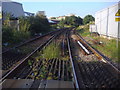
North London line northbound
From level crossing on Bollo Lane
Image: © David Howard
Taken: 28 Sep 2008
0.00 miles
4
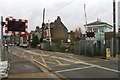
LC in Bollo Lane I, W4
This level crossing is one of two in close proximity is part of the
North London Line.
Image: © Phillip Perry
Taken: 31 Oct 2010
0.03 miles
5
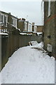
Bridlington Lane
This is simply the back lane to properties on Temple Road and Weston Road, but a few years ago the local council decided to give names to many such public access alleys as a means of providing identification of locations where fly tipping was common. As far as I am aware, there are no house numbers specific to it.
Image: © Alan Murray-Rust
Taken: 19 Dec 2010
0.03 miles
6
Waiting for Bollo Lane Level Crossing
In this instance traffic is waiting for a freight train on the further crossing. The nearer one carries passenger services on the North London Line.
Image: © Peter Whatley
Taken: 6 Apr 2010
0.03 miles
9
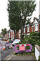
Storm Damage on Weston Road
A Cherry tree has shed a limb during the hurricane of the previous Monday causing minor damage in a neighbouring garden. The housing and the road date to circa 1910.
Image: © Martin Addison
Taken: 31 Oct 2013
0.03 miles
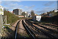
10
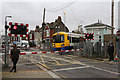
Bollo Lane (Richmond Line) Crossing
London Overground 378204 crosses Bollo Lane with the 12:08 Richmond to Stratford service. Traffic on Bollo Lane can be very heavy and can result in delays to the trains whilst waiting for the crossing barriers to safely close.
On the right is Bollo Lane Junction signal box. It was constructed by the London & South Western Railway in 1878 when Acton Curve was introduced, turning Gunnersbury Junction into a triangle. It was built around 200 yards from the junction it controlled in order to give the signal man good visibility of the Bollo Lane Level Crossing. When the curve closed (late 1960's?) the box only controlled the crossing and its associated signals. In the 1970's the adjacent box on the South Acton Junction - Kew Junctions line was closed and Bollo Lane Junction box took over control of the junction and the second Bollo Lane Level Crossing. In 1983 it took on control of the Level Crossing at Acton Central too - using CCTV to monitor the crossing. In June 2012 the box finally closed as signalling and control of the level crossings passed to Acton Wells. The box is the sole surviving example of the L&SWR's 1877 simple box design - it is to be hoped that its historical importance will be recognised. Fuller details of the box can be found at http://www.signalbox.org/gallery/s/bollolanejcn.php .
Image: © Martin Addison
Taken: 31 Oct 2013
0.04 miles