IMAGES TAKEN NEAR TO
Weston Road, LONDON, W4 5NH
Introduction
This page details the photographs taken nearby to Weston Road, W4 5NH by members of the Geograph project.
The Geograph project started in 2005 with the aim of publishing, organising and preserving representative images for every square kilometre of Great Britain, Ireland and the Isle of Man.

There are currently over 7.5m images from over14,400 individuals and you can help contribute to the project by visiting https://www.geograph.org.uk
Image Map
Images are licensed for reuse under creativecommons.org/licenses/by-sa/2.0
Notes
- Clicking on the map will re-center to the selected point.
- The higher the marker number, the further away the image location is from the centre of the postcode.
Image Listing (196 Images Found)
Images are licensed for reuse under creativecommons.org/licenses/by-sa/2.0
Image
Details
Distance
1
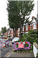
Storm Damage on Weston Road
A Cherry tree has shed a limb during the hurricane of the previous Monday causing minor damage in a neighbouring garden. The housing and the road date to circa 1910.
Image: © Martin Addison
Taken: 31 Oct 2013
0.02 miles
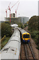
2
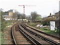
North London Line from Bollo Lane level crossing
Note the third rail supply for the frequent local passenger service. South Acton station is just out of sight around the bend.
Image: © Peter Whatley
Taken: 6 Apr 2010
0.03 miles
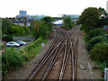
3
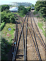
South Acton junction
The left hand tracks are the North London Line route to Gunnersbury and Richmond. The right hand lines provide a freight link to the south western lines at Kew.
Image: © Alan Murray-Rust
Taken: 22 Jul 2008
0.03 miles
5
South Acton Junction
London Overground trains bound for Richmond and Stratford pass each other at the junction to the southwest of South Acton station. The tracks on curving to the left connect the North London Line to the London Underground Richmond branch of the District Line at Gunnersbury Junction. The tracks on the right are normally freight only and connect to the South Western Brentford Loop at Old and New Kew Junctions - either side of Kew Bridge station.
Image: © Martin Addison
Taken: 31 Oct 2013
0.03 miles
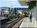
6
Tracks near South Acton station
Viewed from the station footbridge.
Image: © Thomas Nugent
Taken: 9 Oct 2011
0.03 miles
7
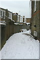
Bridlington Lane
This is simply the back lane to properties on Temple Road and Weston Road, but a few years ago the local council decided to give names to many such public access alleys as a means of providing identification of locations where fly tipping was common. As far as I am aware, there are no house numbers specific to it.
Image: © Alan Murray-Rust
Taken: 19 Dec 2010
0.03 miles
8
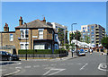
Old Shop behind a Hedge
Former corner shop on Weston and Kingwood Roads
Image: © Des Blenkinsopp
Taken: 13 May 2019
0.03 miles
9
South Acton Station
North London Line train arriving from Richmond. This line has recently been taken under the wing of Transport for London, under the Overground brand. TfL has made significant improvements to stations on the line, including fresh paint, full time staff and hanging flower baskets.
Image: © Alan Murray-Rust
Taken: 22 Jul 2008
0.04 miles
10
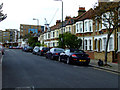
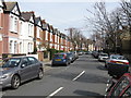
kingswood Road
Looking towards South Acton railway station.
Image: © Thomas Nugent
Taken: 9 Oct 2011
0.04 miles