IMAGES TAKEN NEAR TO
Magnolia Road, LONDON, W4 3RB
Introduction
This page details the photographs taken nearby to Magnolia Road, W4 3RB by members of the Geograph project.
The Geograph project started in 2005 with the aim of publishing, organising and preserving representative images for every square kilometre of Great Britain, Ireland and the Isle of Man.

There are currently over 7.5m images from over14,400 individuals and you can help contribute to the project by visiting https://www.geograph.org.uk
Image Map
Images are licensed for reuse under creativecommons.org/licenses/by-sa/2.0
Notes
- Clicking on the map will re-center to the selected point.
- The higher the marker number, the further away the image location is from the centre of the postcode.
Image Listing (190 Images Found)
Images are licensed for reuse under creativecommons.org/licenses/by-sa/2.0
Image
Details
Distance
1
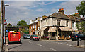
Thames Road
Seen at the junction with Magnolia Road. On the left is the bridge and embankment carrying the Richmond to Gunnersbury railway line.
Image: © Martin Addison
Taken: 7 May 2010
0.05 miles
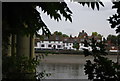
2

The Kew Railway bridge from the South Bank
Close to it is almost completely hidden by the waterside belt of trees, and I had to look hard to find this break in the foliage. Better views are available from Kew Bridge Image or from the north (Chiswick) bank - Image by Colin Smith and Image by Nigel Cox.
Image: © Chris Reynolds
Taken: 1 Jun 2009
0.06 miles
3

The Bull's Head Public House, The Strand on the Green, seen from under the Kew Railway Bridge
Image: © Chris Reynolds
Taken: 1 Jun 2009
0.07 miles
6
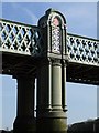
Kew Railway Bridge: unexpected architectural detail
At a glance the design of this lattice-girder bridge appears entirely functional. Look more closely and you find that the piers are embellished with fanciful architectural detail. The bridge was built in 1869 by the London & South Western Railway, as part of their route from Kensington to Richmond (later taken over by the District Railway). The Victorian engineer who designed it tricked out the piers as classical columns, perhaps with a hint of the Egyptian flavour which was fashionable at the time.
Image: © Stefan Czapski
Taken: 10 Apr 2011
0.08 miles
7
Strand-on-the-Green : "The Bull's Head" public house
Grade II listed - description at this https://historicengland.org.uk/listing/the-list/list-entry/1356694.
Image: © Jim Osley
Taken: 11 Mar 2018
0.08 miles
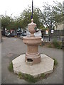
8
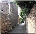
Post Office Alley
The alley runs between Thames Road and Strand on the Green.
Image: © PAUL FARMER
Taken: 19 Sep 2009
0.09 miles
9
Post Office Alley
Leading between Thames Road and the riverside walk Strand-on-the-Green, this alley got its name because it actually led to a post office, though where that building was I have been unable to ascertain. The houses at the end look as if they block the path but the one on the left, which dates to 1752, has its first floor built over the path and a low narrow tunnel at ground level allow access through the property to the riverside walk.
Image: © Martin Addison
Taken: 7 May 2010
0.09 miles
10
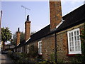
Hopkin Morris Cottages
These were built as almshouses in 1724
Image: © PAUL FARMER
Taken: 19 Sep 2009
0.09 miles