IMAGES TAKEN NEAR TO
Magnolia Road, LONDON, W4 3QN
Introduction
This page details the photographs taken nearby to Magnolia Road, W4 3QN by members of the Geograph project.
The Geograph project started in 2005 with the aim of publishing, organising and preserving representative images for every square kilometre of Great Britain, Ireland and the Isle of Man.

There are currently over 7.5m images from over14,400 individuals and you can help contribute to the project by visiting https://www.geograph.org.uk
Image Map
Images are licensed for reuse under creativecommons.org/licenses/by-sa/2.0
Notes
- Clicking on the map will re-center to the selected point.
- The higher the marker number, the further away the image location is from the centre of the postcode.
Image Listing (209 Images Found)
Images are licensed for reuse under creativecommons.org/licenses/by-sa/2.0
Image
Details
Distance
1
Thames Road
Seen at the junction with Magnolia Road. On the left is the bridge and embankment carrying the Richmond to Gunnersbury railway line.
Image: © Martin Addison
Taken: 7 May 2010
0.08 miles
2

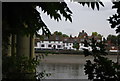
The Kew Railway bridge from the South Bank
Close to it is almost completely hidden by the waterside belt of trees, and I had to look hard to find this break in the foliage. Better views are available from Kew Bridge Image or from the north (Chiswick) bank - Image by Colin Smith and Image by Nigel Cox.
Image: © Chris Reynolds
Taken: 1 Jun 2009
0.09 miles
3
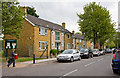
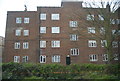
Housing on Thames Road
Post-war housing on Thames Road. The board on the right refers to Strand-on-the-Green Recreation Ground which is located behind these dwellings.
Image: © Martin Addison
Taken: 7 May 2010
0.10 miles
4

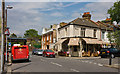
The Bull's Head Public House, The Strand on the Green, seen from under the Kew Railway Bridge
Image: © Chris Reynolds
Taken: 1 Jun 2009
0.10 miles
5
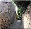
Post Office Alley
The alley runs between Thames Road and Strand on the Green.
Image: © PAUL FARMER
Taken: 19 Sep 2009
0.11 miles
6
Post Office Alley
Leading between Thames Road and the riverside walk Strand-on-the-Green, this alley got its name because it actually led to a post office, though where that building was I have been unable to ascertain. The houses at the end look as if they block the path but the one on the left, which dates to 1752, has its first floor built over the path and a low narrow tunnel at ground level allow access through the property to the riverside walk.
Image: © Martin Addison
Taken: 7 May 2010
0.11 miles
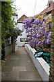
10
Strand on the Green
Strand on the Green is a narrow picturesque walkway on the river, running east from Kew Bridge, with varied vintage houses and pubs along its length.
Image: © Chris Gunns
Taken: 20 Jul 2002
0.11 miles