IMAGES TAKEN NEAR TO
Ship Alley, LONDON, W4 3PT
Introduction
This page details the photographs taken nearby to Ship Alley, W4 3PT by members of the Geograph project.
The Geograph project started in 2005 with the aim of publishing, organising and preserving representative images for every square kilometre of Great Britain, Ireland and the Isle of Man.

There are currently over 7.5m images from over14,400 individuals and you can help contribute to the project by visiting https://www.geograph.org.uk
Image Map
Images are licensed for reuse under creativecommons.org/licenses/by-sa/2.0
Notes
- Clicking on the map will re-center to the selected point.
- The higher the marker number, the further away the image location is from the centre of the postcode.
Image Listing (299 Images Found)
Images are licensed for reuse under creativecommons.org/licenses/by-sa/2.0
Image
Details
Distance
1
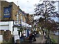
The City Barge
Historic Thames-side pub which gets its name from The Lord Mayor of London visiting here by barge.
Image: © Colin Smith
Taken: 29 Mar 2009
0.01 miles
2
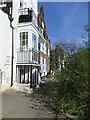
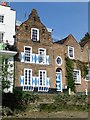
Houses along Strand on the Green, Chiswick
What I like about Strand on the Green is that it so obviously dates from the days before the motor car, and it's still not making any concessions: front doors here are accessible only from the narrow path along the river bank. Even that can get a bit overgrown, as seen in this shot.
The white-painted house is Compass House, a grade-2 listed building dating from about 1800. At ground level there is an array of black-painted cast-iron columns, supporting the entrance porch, one floor up - very curious.
Image: © Stefan Czapski
Taken: 10 Apr 2011
0.01 miles
3
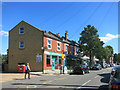
Strand on the Green Post Office
In Thames Road, one block in from the river.
Image: © Des Blenkinsopp
Taken: 8 Sep 2016
0.01 miles
4
Strand on the Green
Strand on the Green is a narrow picturesque walkway on the river, running east from Kew Bridge, with varied vintage houses and pubs along its length.
Image: © Chris Gunns
Taken: 20 Jul 2002
0.01 miles
5
The Dutch House, Strand on the Green
Seen from the muddy Thames foreshore, at low tide. This house catches the eye because of its shutters, painted in the Dutch manner with a split-diamond design. As with a few other houses along Strand on the Green, the gable, too, is in the Dutch style, with convex and concave curves. The shutter decoration is often to be seen in Holland, on older buildings - but the colours are almost always red and white - so why, I wonder, did the owners of this house choose blue ?
To see how close the river can come to the Dutch House at high tide see: Image
Image: © Stefan Czapski
Taken: 10 Apr 2011
0.01 miles
6
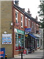
Chiswick: Strand-on-the-Green Post Office
The post office is at 54 Thames Road, the first of a row of shops, but the road just behind us is Strand-on-the-Green, like the suburb name. There has been a post office hereabouts since 1 August 1876, apart from a closure between November 1900 and July 1908.
Image: © Chris Downer
Taken: 12 Sep 2014
0.02 miles
7
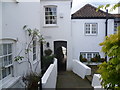
Tunnel Cottage at Strand-on-the-Green
The riverfront at Strand-on-the-Green consists of a footpath running along the bank of the River Thames. It is overlooked by fine 18th-century houses and a collection of riverside pubs, and as it is on the tideway is regularly flooded by the river, especially when high tide combines with heavy flow from upriver as here in November 2012. The entrance of all the properties is raised above the path so that the view of the river is not spoiled. This is one of the passageways leading from Thames Road to the riverside footpath. The flooded river was literally on the other side of Tunnel Cottage.
Image: © Marathon
Taken: 28 Nov 2012
0.02 miles
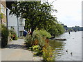
8
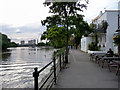
Towpath, North Bank of The Thames at Kew
As seen from the City Barge.
Image: © Christine Matthews
Taken: 11 May 2011
0.02 miles
9
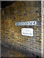
Ship Alley, Kew, London W4
As seen from Thames Road.
Image: © Christine Matthews
Taken: 11 May 2011
0.03 miles
10
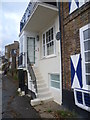
Steps to front door along the riverfront at Strand-on-the-Green
The riverfront at Strand-on-the-Green consists of a footpath running along the bank of the River Thames. It is overlooked by fine 18th-century houses and a collection of riverside pubs, and as it is on the tideway is regularly flooded by the river, especially when high tide combines with heavy flow from upriver as here in November 2012. The entrance of all the properties is raised above the path so that the view of the river is not spoiled. This is a typical example. In some cases, however, this has left rather strange effects such as front doors which are only four feet high - see http://www.geograph.org.uk/photo/2123728
Image: © Marathon
Taken: 28 Nov 2012
0.03 miles