IMAGES TAKEN NEAR TO
Strand On The Green, LONDON, W4 3PD
Introduction
This page details the photographs taken nearby to Strand On The Green, W4 3PD by members of the Geograph project.
The Geograph project started in 2005 with the aim of publishing, organising and preserving representative images for every square kilometre of Great Britain, Ireland and the Isle of Man.

There are currently over 7.5m images from over14,400 individuals and you can help contribute to the project by visiting https://www.geograph.org.uk
Image Map
Images are licensed for reuse under creativecommons.org/licenses/by-sa/2.0
Notes
- Clicking on the map will re-center to the selected point.
- The higher the marker number, the further away the image location is from the centre of the postcode.
Image Listing (293 Images Found)
Images are licensed for reuse under creativecommons.org/licenses/by-sa/2.0
Image
Details
Distance
1
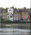
The Dutch House and its neighbours, Strand on the Green
Seen across the river from Kew.
The diamond pattern painted on the shutters of the Dutch House is very much in the Dutch tradition. I notice that since I was here last year, shutters and door have been repainted using a darker shade of blue http://www.geograph.org.uk/photo/2352960
On this occasion the tide was out. For an impression of the scene at high water see http://www.geograph.org.uk/photo/2318379
Image: © Stefan Czapski
Taken: 19 May 2012
0.01 miles
2
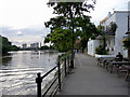
Towpath, North Bank of The Thames at Kew
As seen from the City Barge.
Image: © Christine Matthews
Taken: 11 May 2011
0.01 miles
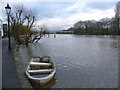
3
The riverfront at Strand-on-the-Green
Taken at low tide on a rather grey and misty day, the trees on the right are on the island of Oliver's Ait. The island gets its name from Oliver Cromwell.
Image: © Marathon
Taken: 8 Sep 2010
0.01 miles
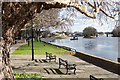
4
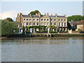
Strand on the Green, Kew
A terrace on the bank of the River Thames at Strand on the Green, Kew.
Image: © Malc McDonald
Taken: 2 Jul 2011
0.01 miles
5
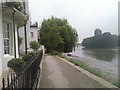
The riverfront at Strand-on-the-Green
The riverfront at Strand-on-the-Green consists of a footpath running along the bank of the River Thames. It is overlooked by fine 18th-century houses and a collection of riverside pubs, and as it is on the tideway is regularly flooded by the river, especially when high tide combines with heavy flow from upriver. The entrance of all the properties is raised above the path so that the view of the river is not spoiled. In some cases this has left rather strange effects such as front doors which are only four feet high - see http://www.geograph.org.uk/photo/2123728 In the distance is the railway bridge erected in 1869 which is now used by both the District Line and London Overground. The trees on the right are on the island of Oliver's Ait. The island gets its name from Oliver Cromwell. It acquired its name after rumours that Oliver Cromwell used the island as a hideout and held military councils at the Bull's Head pub during the English Civil War. These rumours seem somewhat unlikely.
Image: © Marathon
Taken: 28 Nov 2012
0.01 miles
7
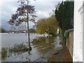
Flooding along the riverfront at Strand-on-the-Green
The riverfront at Strand-on-the-Green consists of a footpath running along the bank of the River Thames. It is overlooked by fine 18th-century houses and a collection of riverside pubs, and as it is on the tideway is regularly flooded by the river, especially when high tide combines with heavy flow from upriver as here in November 2012. The entrance of all the properties is raised above the path so that the view of the river is not spoiled. An example is seen just ahead, but in some cases this has left rather strange effects such as front doors which are only four feet high - see http://www.geograph.org.uk/photo/2123728 Kew Bridge can be seen in the distance.
Image: © Marathon
Taken: 28 Nov 2012
0.02 miles
8
Steps to front door along the riverfront at Strand-on-the-Green
The riverfront at Strand-on-the-Green consists of a footpath running along the bank of the River Thames. It is overlooked by fine 18th-century houses and a collection of riverside pubs, and as it is on the tideway is regularly flooded by the river, especially when high tide combines with heavy flow from upriver as here in November 2012. The entrance of all the properties is raised above the path so that the view of the river is not spoiled. This is a typical example. In some cases, however, this has left rather strange effects such as front doors which are only four feet high - see http://www.geograph.org.uk/photo/2123728
Image: © Marathon
Taken: 28 Nov 2012
0.02 miles
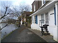
9
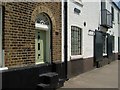
Buildings at Strand-on-the-Green
The front door is raised above the walkway in case of high tides - this faces the Thames. No 49, with its attractive fanlight, is listed http://www.imagesofengland.org.uk/Details/Default.aspx?id=438647&mode=adv . Next door was "originally a malthouse or warehouse", and runs back to Thames Road http://www.imagesofengland.org.uk/Details/Default.aspx?id=438646&mode=adv .
Image: © Derek Harper
Taken: 9 Jun 2005
0.02 miles
10
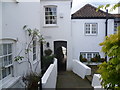
Tunnel Cottage at Strand-on-the-Green
The riverfront at Strand-on-the-Green consists of a footpath running along the bank of the River Thames. It is overlooked by fine 18th-century houses and a collection of riverside pubs, and as it is on the tideway is regularly flooded by the river, especially when high tide combines with heavy flow from upriver as here in November 2012. The entrance of all the properties is raised above the path so that the view of the river is not spoiled. This is one of the passageways leading from Thames Road to the riverside footpath. The flooded river was literally on the other side of Tunnel Cottage.
Image: © Marathon
Taken: 28 Nov 2012
0.03 miles